Ocean Drilling Program Leg 191 had two main goals:
(1)
to drill and case a borehole at a site in the northwest Pacific Ocean,
between Japan and the Shatsky Rise and install therein a seismic observatory.
The seismic observatory was successfully installed at Site 1179 and left ready for
activation by a future ROV cruise. During Late 2000, the system was
successfully started and data were obtained from the borehole seismometer.
(2)
to test the drilling and casing emplacement capabilities of the Hard Rock
Re-entry System (HRRS or hammer drill) on a basaltic outcrop at Shatsky Rise.
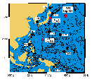
Figure 1: Location map of seismic station coverage in the northwest Pacific. Black
circles indicate land seismic stations, whereas red circles are current and
proposed seafloor borehole observatories. Leg
186 (Site 1150 and 1151), Leg 191
(Site 1179) and future Leg 195 (planned Site WP-1) locations are reported on this map.
Abbreviations: YSS: Yuzhno Sakhalinsk, Russia, NMR: Nemuro, Japan, HCH: Hachijo-shima, Japan, PHN: Pohang, Korea, OGS: Chichi-jima, Japan, MCSJ: Minami-tori-shima, Japan, ISG: Ishigaki, Japan, TGY: Tagaytay, Philippines, PATS: Ponsei, Mictonesia, PMG: Port Moresby, Papua New Guinea.
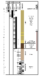
Site 1179:
Site 1179 is located in the
northwest Pacific Ocean, East of Japan (Figure 1), in lithosphere of anomaly M8 age (129 m.y.). Five holes were drilled at Site 1179 (Figure
2). Cores were
recovered in Holes A-B-C and D at various depths. A sedimentary column of 377 m thick
was cored (Holes A, B, and C) in addition to 98 m of basaltic basement (Hole D).
Hole E was devoted to the seismometer installation. The sedimentary column has
been divided into four lithologic units (Scientific Party).
Unit I consists of 223.5 m of clay
and radiolarian-bearing diatom ooze of late Miocene to recent age. Ash beds are
common in this unit, recording volcanic activity from the western Pacific island
arcs.
Unit II is a clay-rich and
diatom-bearing radiolarian ooze of late Miocene age with a thickness of 22.5 m.
Unit III contains barren, brown pelagic
clay in a layer 37.5 m in thickness.
Unit IV yielded poor recovery with
only chert and porcellanite fragments from an unknown sedimentary matrix within
93.7 m above basement.
Basement: The 98 m igneous section
consists of Early Cretaceous aphyric ocean ridge basalts. The section consists
of massive flows and pillows with small amounts of inter-unit sediments and
volcanic breccias.
Figure 2: Lithologic summary column for Site 1179.
Objectives
Geophysical measurements were
important for the long-term seismic observatory installation. The logging
program was initially designed to measure the physical properties, hole shape,
porosity, in situ stress and fracture characteristics of the sediments and
basement. To achieve these objectives the initial logging plan included Triple
Combo, FMS-Sonic and UBI.
Logging
Operations
The Triple Combo tool string was first deployed for physical measurements. It includes the Accelerator Porosity Sonde (APS), the Hostile Environment Natural Gamma Sonde (HNGS), the High Temperature Lithodensity Tool (HLDT), the Phasor Dual Induction Spherically Focused Resistivity Tool (DIT-E) and the Temperature / Acceleration / Pressure Tool (TAP). The new LDEO high resolution Multisensor Gamma-ray Tool (MGT) was attached to the top of the toolstring.
Downhole
conditions prevented the complete drilled interval from being logged.
The first triple combo pass was logged from 300 to 203 mbsf with the standard
triple combo probes. After this pass, the tool string was again lowered but a bridge was encountered at about 260 mbsf. After several
unsuccessful attempts to pass the tool string through the bridge, only the upper
part of the borehole was logged and the remaining passes started from this
point. The second and third passes were used for recording MGT data only and the
fourth pass to run the standard Triple Combo.
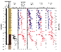
Data quality
Poor borehole conditions ranging from washed
out to constricted along the whole logged
interval resulted in poor quality logs, especially for tools that require
eccentralization and good contact between the tool and the borehole wall (APS
and HLDT). Caliper data are very rough (Figure 3), ranging from 7 up to 16.5
inches. From 246 mbsf to the pipe depth, the caliper remained fully opened (16.5
in. which is the full range of the tool). Furthermore, the HLDT developed a
functioning problem with the far spaced detector resulting in erroneous spikes
in the density and photoelectric measurements. Despite the degraded borehole
conditions, gamma ray (both HNGS and MGT) and resistivity (DITE) produced good
quality data and recorded the lithologic changes well.
Figure 3: Natural radioactivity measurements (HNGS and MGT) in Hole 1179D are shown with caliper data and lithologic units determined from core description from Hole 1179C. The MGT natural radioactivity measurements are in CPS (counts per second) and the HNGS measurements are in API units.
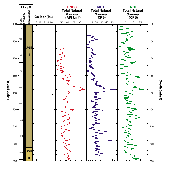
Natural
Radioactivity
Natural radioactivity was measured downhole by both the HNGS and the newly developed MGT. Both tools have scintillation detectors that measure the natural gamma radiation emitted by the formation due to radioactive decay. In general the total gamma-ray record shows an overall increase in natural radioactivity with depth (Figure 3). There is, however, a significant decrease in the log data at 246 mbsf, this correlates with similar tool responses at this depth for resistivity, and is probably linked to the tool response due to the poor hole conditions at this depth (caliper jumping from 7 to 16.5 in.). A number of distinctive peaks in the gamma ray measurements occur in the uppermost part of the logged section at depths of 182.9, 188.0, 195.7, and 242.2 mbsf and correspond to occurrences of ash layers described in the sediment cores.
The data from the MGT are well correlated with total counts from the HNGS and core data (Multi Sensor Track). The MGT measurements present much higher vertical resolution and they allow a better identification of the layers (Figure 4).
Figure 4: Natural radioactivity measurements in Hole 1179D, comparison between the HNGS and the newly developed MGT. On this graph are also reported the Hole 1179C core natural radioactivity measurements
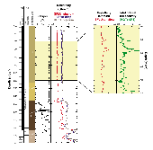
Electrical
Measurements
The resistivity data clearly
delineate the main lithologic types observed in the sediment column at Hole
1179C (Figure 5). The electrical
resistivity in lithologic Unit I (ooze) is low, with small increases in
resistivity at 180, 188, 200 and 212 mbsf. These increases could be associated
with ash layers or burrows noted in the core description and gamma ray
measurements. The boundary between Units I and II is marked by a slight increase
in resistivity (only 0.01 Ohm.m of difference between Unit I and II). The DIT
data clearly recorded the lithologic change between Unit II and III, marked by
an increase in the electrical resistivity at 243 mbsf. The boundary between
lithologic Units III and IV is marked by a strong increase in resistivity (from
0.7 to 3.5 Ohm.m). The chert layer consists of alternating high resistivity
layers (nodules) and interbedded low resistivity layers (clay rich layers).
Figure 5: Electrical measurements in Hole 1179D are shown with caliper data and lithologic units determined from core description from Hole 1179C. The diagram shows the good correlations between natural radioactivity and resistivity measurements. Both measurements allow the ash layer identification, marked by increase in resistivity and natural gamma ray.
Logging Scientists:
Florence
Einaudi - Logging Staff Scientist -
Laboratoire de Mesures en Forage, ODP NEB, ISTEEM, cc49 Universite de Montpellier II 34 095 Montpellier Cedex France
Alex Meltser - Logging Engineer -
Lamont-Doherty Earth Observatory, Columbia university, Borehoel Research Group, Palisades, NY 10964, USA
Sarah Haggas - JOIDES Logger -
Department of Geology, University of Leicester, Leicester, LE1 7RH, UK
Proceedings of the Ocean Drilling Program, Initial Reports
Proceedings of the Ocean Drilling Program, Scientific Results