ODP Leg 195 drilled three sites, each with very different scientific objectives (see Leg 195 Scientific prospectus):
This report presents the preliminary results of the logging operations that were carried out during the leg. Detailed descriptions of the preliminary results and conclusions of the leg will be available in the Leg 195 Preliminary Report.
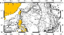
Figure 1. Map showing the locations of the three sites drilled during ODP Leg 195.
Although downhole logging was planned at all three sites, it was only attempted at Sites 1201 and 1202. Hole conditions at the South Chamorro serpentine mud volcano proved unfavourable for logging. At Site 1201 a full suite of wireline logs were obtained (see description below), and at Site 1202 logging operations were aborted after vibration of the tool string within the drill pipe resulted in the loss of the Lamont TAP (Temperature, Acceleration, Pressure) tool.
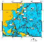
Figure 2. Map showing the location of Site 1201 (WP-1B) and seismic station coverage in the northwest Pacific. Solid circles are land based seismic stations and open circles are seafloor borehole observatories (see Leg 195 Scientific Prospectus for more detail).
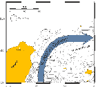
Figure 3. Map showing the location of Site 1202 (KS-1) and the approximate path of the Kuroshio Current.
Wireline logging operations were carried out in Hole 1201D, the pilot hole drilled prior to installation of the seismometer package. During logging, the base of the drill string was kept at 76.5 mbsf to prevent borehole collapse in the upper soft sediment section. The depth to the seafloor was determined to be 5723 mbrf based on changes in the density and porosity logs at that depth. Two toolstrings were run during wireline logging operations: the triple combo (temperature, resistivity, density, porosity, and natural gamma); and the FMS-sonic combination (Formation MicroScanner, sonic wave velocity, natural gamma ray). The first run with the triple combo toolstring reached total depth at 591 mbsf after encountering sticky intervals at around 107 mbsf, just below where the pipe was set, and between 417 and 467 mbsf (figure 4). There was no apparent geological reason why this particular interval should have been sticky and difficult to penetrate. The hole was logged up from total depth, past the basement contact at 512 mbsf and up to 417 mbsf, where the caliper was closed to get through the tight spot. Logging ceased at this point and restarted again just above the tight spot. Logging continued from there up to the sea floor at 5723 mbrf, however no Dual Laterolog resistivity data were recorded in the uppermost interval (figure 5). During the run with the FMS-sonic toolstring, some difficulty was encountered getting the toolstring out of the pipe and pump pressure with circulation was applied to wash material out of the end of the pipe. An obstruction that could not be passed was encountered at 350 mbsf, higher up than the tight interval found on the first run (figure 4). On the first pass the FMS calipers did not open fully until 250 mbsf. The hole was logged up to 117 mbsf at which point the toolstring was lowered again for a second pass. The second pass commenced 15 meters deeper at 366 mbsf and was successfully logged up to the pipe depth at 82 mbsf.
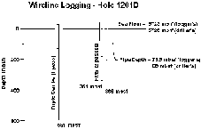
Figure 4. Logging operations summary diagram showing the intervals logged with the triple combo and FMS-sonic toolstrings and the pipe and seafloor depths.
The hole conditions were good in basement, with the caliper measurements showing a hole diameter varying between 10 and 11.5". In the sediment section, the caliper measurement varied from 12-18.5" with a couple of tight spots below bit
size (figure 5). During logging operations in Hole 1201D a speed correction was applied
as a default by the Schlumberger acquisition software. When this speed correction was removed and the data
were restored to measured depth, some of the high resolution data were lost, resulting in straight line sections on
the high resolution density and porosity curves. Despite this, preliminary observation suggests that the conventional standard logs are still of
reasonable quality. The data from the
log runs that were recorded above and below the tight spot were spliced at 396.5 mbsf, although
a small gap remains in the gamma-ray and porosity log data (figure
5). The readings on the gamma ray curve measured just above the tight spot may be slightly elevated because of prior activation of the formation by the neutron source. The density logs are unreliable over a short interval between 451 and 444 mbsf, where the long spacing voltage became unstable.
There are two erroneous spikes on the shallow laterolog curve between 412 and 417 mbsf,
and at 297 mbsf. The repeat measurements of all logs compare well and demonstrate the good quality of the standard resolution geophysical logs.
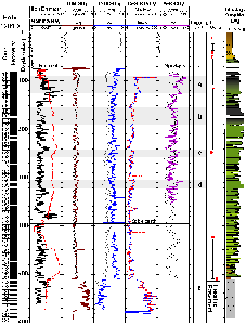
Figure 5. Summary of downhole logging results in Hole 1201D; caliper, total gamma ray emission, density, porosity, resistivity, and sonic velocity logs are shown. The depths of the pipe and the splice between the two uplogs are marked. The asterisks indicate spurious data or spikes. Logging units are marked and coarser turbiditic beds a-d are highlighted with grey shading. Laboratory physical properties measurements of the density, porosity and sonic velocity of core material are also plotted along with the graphic lithology log based on core descriptions.
Two logging units have been identified. Logging Unit 1 corresponds to lithostratigraphic Unit II, and logging Unit 2 corresponds to the underlying basaltic basement. Lithostratigraphic Unit I was not logged because it only extends to about 60 mbsf and the base of the pipe was set at 76.5 mbsf during logging. The log data show a good correlation with the physical properties measurements made on cores, particularly the discrete sample density and velocity measurements. The porosity measurements from the logs are higher than the measurements made on discrete core samples because the neutron porosity log responds to the presence of hydrogen in the formation and also measures bound water and fracture porosity (Schlumberger, 1989; Rider, 1996). The logs show no obvious trends with depth other than a step change at the contact between the sediment and the basaltic basement, which is marked by a sharp increase in resistivity and density and a corresponding decrease in porosity. Both logging units appear to be relatively homogeneous but include subtle variations which reflect changes in lithology.
Turbiditic Sediments
The turbiditic sediments (logging Unit 1) extend from the base of the pipe at 76.5 mbsf to the basement contact at 512 mbsf. The logs are consistent over this entire interval, which demonstrates the fairly homogenous nature of the reworked volcaniclastic sediment that dominates the unit. Recovery was high (> 80%), which facilitates detailed core-log correlation studies. The sediments consist of a series of low to high energy turbidite sequences, characterized by alternating claystone-rich and coarser sandstone-rich or breccia intervals. The logging data show small variations in resistivity, velocity, density, porosity, and gamma ray values, reflecting changes in lithology, porosity, and grain size. Within logging Unit 1, four intervals that correspond to thicker, coarser turbidite packages can be recognized in the logging data (the grey shaded intervals a-d in figures 5 and 6 occurring at 90-124 mbsf, 155-190 mbsf, 242-257 mbsf, and 305-322 mbsf). These intervals are characterized by higher and more consistent velocity, density, and resistivity values and slightly lower and more consistent natural gamma ray values. They represent more massive sandstone or breccia intervals with smaller scale grain size variations that can also be identified in the log response. Between these intervals the logs show more rapid fluctuations, with generally lower velocity, density, and resistivity values and slightly higher and more variable gamma ray values, corresponding to interbedded finer-grained units.
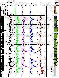
Figure 6. Summary of natural gamma ray logs in Hole 1201D; total gamma ray emission, potassium, thorium, uranium, and PEF curves are displayed alongside the graphic lithology log. Logging units are marked and coarser turbiditic beds a-d are highlighted with grey shading.
Basement
The basement section (logging Unit 2) extends from 512 mbsf down to 591 mbsf and is marked by a significant increase in density, resistivity, and velocity values and a corresponding decrease in porosity values (figure 5). The resistivity values, although significantly higher than those recorded in logging Unit 1, are not as high as expected for a massive basalt lava sequence. Instead they are comparable to values that have been reported from pillow lavas with interpillow breccia. Core recovery in basement was relatively poor (< 23.1%) and included small pieces (< 30 cm) of veined basalt with occasional glassy pillow margins and interpillow material, including highly altered hyaloclastite. This is consistent with the interpretation of this unit as a pillow sequence with some interpillow breccia, rather than as massive basalt flows. The basement section is relatively homogenous and contains no obvious boundaries, although there appears to be a slight increase in resistivity and a decrease in gamma ray values with depth which may indicate a trend toward slightly less altered material deeper in the basement section.
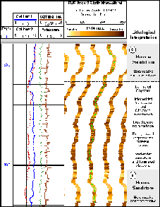
Figure 7. FMS images from a coarse turbidite-laminated claystone interval between 240 and 320 mbsf in Hole 1201D. The "spiky" and blocky features observed on the gamma ray curve are an artifact of the malfunctioning speed correction.
The FMS images and natural gamma ray measurements from the FMS-sonic toolstring were particularly affected by the default speed correction. There are stretched or compressed intervals and spikes in the data, and much of the textural detail on the images has been lost. The FMS images in Figure 7 are from a coarse turbidite-claystone sequence between 240 and 320 mbsf. Despite the effects of the speed correction, the resistivity difference between the coarser massive units and the finer interbedded sequences is immediately obvious on the static normalized image. Individual bed boundaries can be delineated easily and can be used for core-log integration studies.
Despite the problems that hampered logging operations at Site 1201, good data were obtained over the entire open hole interval (76.5 to 591 mbsf) with the triple combo toolstring and reliable sonic data were recorded down to 366 mbsf during the second run with the FMS-sonic toolstring. The logging data correlate well with core physical properties measurements. Lithological Unit I did not occur within the logged interval, but the boundary between lithological Unit II (logging Unit 1) and the underlying basement (logging Unit 2) can be clearly delineated. The upper section (logging Unit 1) is characterized by a sequence of turbidites with varying proportions of sandstone or breccia and silty claystone intervals. No obvious trend in density, porosity, resistivity, or velocity with depth is apparent, however, the downhole logs show subtle but significant variations within the turbiditic sedimentary sequence. The basement section (logging Unit 2) is relatively homogenous although there may be a trend toward slightly less altered material with depth.
Rider, M., 1996. The geological interpretation of well-logs, second edition. Whittles Publishing, Caithness.
Schlumberger, 1989. Log Interpretations/Applications: (Wireline and Testing): Houston, TX (Schlumberger).
Samantha Barr: ODP Logging Staff Scientist, E-mail srb7@leicester.ac.uk, Department of Geology, University of Leicester, University Road, Leicester, LE1 7RH, UK.
Philippe Gaillot: ODP Logging Trainee, E-mail gaillot@dstu-montp2.fr, Laboratoire de Mesures en Forage, ISTEEM, Universit de Montpellier 2, Place Eugène Bataillon, CC 49, F-34095 Montpellier cedex 5.
(page will open in a new window)
Proceedings of the Ocean Drilling Program, Initial Reports
Proceedings of the Ocean Drilling Program, Scientific Results