Leg 198 Shipboard Scientific Party
The mid-Cretaceous (~125-85 Ma) and early Paleogene (~60-45 Ma) were characterized by some of the most equable climates of the Phanerozoic and are among the best known ancient "greenhouse" climate intervals. In addition, these intervals contain some of the most abrupt and transient climatic changes in the geologic record, including the late Paleocene thermal maximum (LPTM), the mid-Maastrichtian deep-water event (MME), and the early Aptian oceanic anoxic event (OAE1a). These critical transitions involved dramatically modified oceanic circulation patterns, profound changes in geochemical cycling, and abrupt turnover in marine biotas.
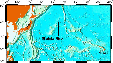
The objectives of ODP Leg 198 on Shatsky Rise were to address the origin and consequences of both the abrupt climatic events and the long-term climatic transition into and out of "greenhouse" climate. Shatsky Rise, a medium-sized large igneous province (LIP) in the west-central Pacific (Figure 1), contains sediments of Cretaceous and Paleogene age at relatively shallow burial depths on three prominent highs. As a result, sediments of both ages could be reached readily through drilling, and fossil materials are sufficiently well preserved for stable isotope and trace element analyses and for faunal and floral assemblage studies.
Eight sites were drilled during Leg 198 on a broad depth transect designed to characterize changes in the nature of surface and deep waters through time, including vertical gradients of temperature, oxygenation, and corrosiveness. Six sites were cored on the Southern High, and one each on the Central and Northern Highs (Figure 2).
A summary of the Leg 198 scientific results can be found in the Preliminary Report
Figure 1. Map showing the location of Shatsky Rise. Leg 198 sailed from Yokohama, Japan, to Honolulu, Hawaii.
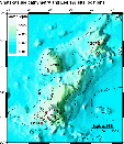
Figure 2. Bathymetric map of Shatsky Rise, showing the South, Central, and North Highs, and the location of the drill sites. Sites 1207 and 1213 were logged.
Holes 1207B and 1213B were logged during Leg 198. Both were RCB holes in low-recovery chert-rich Cretaceous chalk and ooze. The most important logs for the scientific objectives were the FMS resistivity imager (for identifying the form and occurrence of the cherts that had caused the low core recovery), and the natural gamma radiation logs (for identifying black shales).
|
Borehole |
1207B |
1213B |
|
Water depth (mbsl) |
3100.8 |
3882.6 |
|
Penetration (mbsf) |
622.8 |
494.4 |
|
Logged age |
Cretaceous |
Early Cretaceous |
|
Triple Combo depths (mbsf) |
125-622 |
188-430 |
|
MGT depths (mbsf) |
125-353 |
- |
|
FMS-Sonic depths (mbsf) |
115-383 |
- |
|
GHMT depths (mbsf) |
111-368 |
- |
In Hole 1207B (Figure 3), the Triple Combo (resistivity, density, porosity, and natural gamma radiation tools) reached 622 mbsf, within 1 m of the cored total depth, but the other tools strings did not reach below 383 mbsf due to a hole bridge. The MGT (natural gamma radiation) tool was attached to the top of the Triple Combo, and a one pass of data was recorded with it; for the most part, only the total gamma signal is useful because of the very low gamma radioactivity in the ooze and chert. The FMS obtained excellent FMS images, and the DSI sonic tool obtained good velocity data, considering that the hole was made up of alternating hard and soft layers. There were problems with the GHMT (magnetic field and susceptibility) logs - the GHMT tools were not functioning correctly.
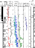
Figure 3. Summary plot of the Hole 1207B logs.
In Hole 1213B, the Triple Combo reached 431 mbsf, 64 m short of the total cored depth. Unfortunately, this meant that we could not log the dolerite sills recovered in the core, or their interface with the sediments. The Triple Combo log was stopped at 188 mbsf, before reaching the pipe, because the tool string became stuck. After about 20 minutes of working it came free. Subsequently the HLDS caliper arm would not close, but the tool string was brought into the pipe without difficulty. An approaching storm forced us to leave the site after the Triple Combo run.
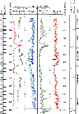
Figure 4. Summary plot of the Hole 1213B logs.
The black shale interval near the base of the Aptian (Ocean Anoxic Event (OAE) 1a) was one of the major objectives of the leg. It is clearly represented as peaks in the natural gamma radiation logs at both of the logged sites (Figure 5, Figure 6). Most of the gamma radiation comes from uranium adsorbed onto the organic matter, and potassium and thorium are also high, indicating the presence of clay in the sediments. The gamma radiation peak at OAE 1a is much stronger than the other peaks in the log: other OAEs are either absent or are weaker than OAE 1a on the Shatsky Rise. Approximately 40 cm of black shale was recovered in Core 1207B-44R, thus it appears that about two-thirds of the interval was not recovered.
The black shale is also apparent in other logs at Hole 1207B: as low density values, because of the low density of organic matter;
and as high porosity values, because the porosity tool detects the amount of
hydrogen in the formation, usually a good indicator of pore water content, but
present here also in the organic matter. The total organic carbon content can be
estimated from the density log. The result is only approximate, because we
assume that the shale and the background sediments have the same porosity, and
adopt values for some densities (e.g. of the organic matter) that are not well
constrained. Following equations in Rider (1996), we found that the organic
matter content is 23.3% by volume and 17.7% by mass, which is approximately the
average of TOC measured by Rock-Eval pyrolysis on the core.
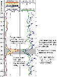
Figure 5. The black shale representing Ocean Anoxic Event (OAE) 1a as recorded in the logs in Hole 1207B.
The black shale layer appears in both Holes 1207B and 1213B, although in Hole 1213B, it appears as a double peak in the uranium log. It is located in a broad high resistivity interval in both holes, and similar patterns of resistivity can be correlated between the holes (Figure 6). This shows that both sites were responding to similar sedimentary input and diagenetic conditions over Albian-Aptian time.
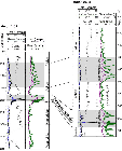
Figure 6. Comparison of the natural gamma radiation and resistivity logs in the Early Cretaceous in Holes 1207B and 1213B.
The FMS (Formation MicroScanner) resistivity images at Hole 1207B reveal the form, thickness, and depths of the chert horizons that formed the bulk of the recovered core below 230 mbsf (Figure 7). Between 210-375 mbsf the chert layers
occur on average every 83 cm and have an average thickness of 9 cm. The cherts
typically appear as layers rather than nodules. Low core recovery in chalk-chert sequences has been the subject of
much discussion, and the image logs from Hole 1207B provide important data to
develop better strategies for core recovery in chalk-chert alternating
sequences.
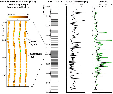
Figure 7. Close-up of an FMS image of chert layers in Hole 1207B. The position and thickness of the cherts were determined from the FMS image for the whole 180-m interval, and are plotted on the right of the figure.
A synthetic seismogram was constructed for Hole 1207B that enabled the core and logs to be correlated with the seismic section, and hence enabled ages to be assigned to the seismic reflectors. GRA densities and Hamilton Frame velocities were used in the upper section where there were no logs. For the log velocity profile, we actually used a resistivity log (IMPH) calibrated to the velocity log, because the original velocity log was only available to 360 mbsf and it contained occasional bad values that caused spurious reflections in the synthetic seismogram. The HLDS density log completed the input data.
The synthetic seismogram was calculated using the IESX software by Schlumberger GeoQuest
(Figure 8). Impedance (velocity x density) was calculated, and the impedance contrast between successive layers gave the reflection co-efficient series. The source wavelet (-90o phase, extracted from the 20 seismic traces surrounding the hole location) was convolved with the reflection coefficient series to give the synthetic seismogram. The synthetic seismogram was stretched and squeezed slightly to line up the synthetic reflections with those in the seismic section, to give the final version shown in Figures 8 and 9. Synthetic seismograms for the other Leg
198 sites, largely based on core physical property measurements, will be
completed post-cruise.
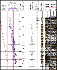
Figure 8. Steps in synthetic seismogram generation for Hole 1207B, including the input density and velocity logs, reflection co-efficient series, and the synthetic. Positive reflections are colored black, and negative reflections in brown.
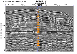
Figure 9. Synthetic seismogram for Hole 1207B, plotted on the seismic section (Line 5A). The locations of significant boundaries found in the cores have been plotted on the seismic section using the synthetic.
Rider, M., 1996. The Geological Interpretation of Well Logs (2nd ed.): Caithness (Whittles Publishing).
Trevor Williams: Logging Staff Scientist, Lamont-Doherty Earth Observatory, Borehole Research Group, Route 9W, Palisades NY 10964 USA. email: trevor@ldeo.columbia.edu
K.T. Moe: Logging Trainee, Institute for Frontier Research on Earth Evolution (IFREE), Japan Marine Science and Technology Center, 2-15 Natsushima Cho, Yokosuka 237-0061, Japan. email: moe@jamstec.go.jp
(page will open in a new window)
Proceedings of the Ocean Drilling Program, Initial Reports
Proceedings of the Ocean Drilling Program, Scientific Results