Logging Scientists
Co-Chief Scientists
Staff Scientist
Shipboard Scientists
Introduction
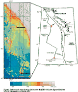
In this document we present a summary of the special downhole experiments and wireline logging results from ODP Leg 169 to the Middle Valley of the northern Juan de Fuca Ridge and the Escanaba Trough of the southern Gorda Ridge (Figure 1). Leg 169 was the second drilling leg to investigate the geological, geophysical, geochemical, and biological processes at sediment-covered spreading centers in the northeast Pacific ocean. In 1991, ODP Leg 139 was primarily focused on establishing the broad scale constraints on hydrothermal circulation of seawater through the upper oceanic crust at sediment-covered spreading centers. Building on these results, the scientific endeavors of Leg 169 were focus on the genesis of massive sulfide deposits by drilling two deposits at different stages of maturity; deposits predominately controlled by a sedimentary source of metals found in the Escanaba Trough and those in the Middle Valley which appear to have both sedimentary and basaltic sources. Details of the overall results of the leg can be found in the Leg 169 preliminary report.
|
Figure 1. Location of sites drilled at the Middle Valley of the northern Juan de Fuca Ridge and the Escanaba Trough of the southern Gorda Ridge during ODP Leg 169. |
Background and Objectives
The specific scientific objectives of the Sedimented Ridges II - ODP Leg 169 were the following:
1) determine the genesis and evolution of massive sulfide deposits by
- understanding the factors that control the location of vigorous, long live hydrothermal
systems capable of forming large massive sulfide deposits;- determining the size and geometry for comparison to on land analogs;
- understanding the timing of mineralization by determining the timing and duration of active hydrothermal discharge;
- determining the distribution and emplacement of metals through out the deposits;
- understanding the constraints that hydrothermal precipitates and alteration minerals place on temperature and composition of the hydrothermal fluids;
- determining the composition of massive sulfide deposits in order to determine the economic value of the deposits;
2) study the tectonics of sedimented rifts and the structural controls of fluid flow by
- examining the spreading mechanisms in both the Middle Valley and the Escanaba Trough;
- determining the composition of massive sulfide deposits in order to determine the economic value of the deposits;
3) examine the hydrologic system of active venting areas by
- performing direct sampling of vent fluids below the seafloor;
- studying the permeability distribution in the sill-sediment complex and its role in the formation of sulfide mineralization;
- examining the vent scale hydrology and the mechanisms responsible for the formation of hydrothermal mounds;
4) study the sedimentation processes and diagenesis by
- drilling a reference section outside the thermal anomalies of the hydrothermal upflow zones in order to quantify the diagenetic and physical properties changes associated with high heat flow and hydrothermal circulation.
Downhole measurements, long-term borehole experiments and the core recovered from the holes drilled during Leg 169 provided the opportunity to address these main objectives.
Middle Valley of the Northern Juan de Fuca Ridge
Operations Summary
A primary objective of downhole operations during Leg 169 was to reCORK Holes 857D and 858G in Middle Valley's Dead Dog hydrothermal field in order to monitor temperatures and pressures during a five year period. The operations began with unsealing the instrumented CORK from Hole 858G (Davis, Mottl, Fisher, et al., 1992; Davis et al., 1992) by removing the data logger and thermistor string, followed by an undisturbed temperature logging run and the first subsurface sampling of hydrothermal fluids from an ODP borehole prior to the recovery of the entire CORK assembly, and finally resealing the hole with a new CORK. Hole 858G operations were scheduled first, to be followed by drilling and logging operations at Hole 856H on the inactive Bent Hill sulfide mound while pressure and thermal conditions equilibrated at Hole 858G. This would set the premise for a proposed hole-to-hole hydrologic experiment which continued with the retrieval of the Hole 857D CORK, located 1.6 km to the south and outside of the active discharge zone (Figure 2).
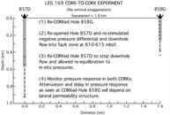 |
Figure 2. Objectives and schematic diagram of the proposed Leg 169 CORK-to-CORK experiment in Holes 857D and 858G, located 1.6 km (Keir Becker and Earl Davis, pers. comm., 1996). The CORK configurations shown are the same as those deployed during Leg 169 as replacements for the thermistor strings and data loggers deployed during Leg 139. |
At this time, the temperature and pressure data recorded in Hole 858G may have detected the transient overpressure induced by the introduction of cold seawater into Hole 857D as it was unsealed during the reCORKing operations. During Leg 139, packer and flowmeter experiments performed in Hole 857D showed a vigorous downhole flow in the order of 20,000 l/min prior to the hole being sealed (Davis, Mottl, Fisher, et al., 1992). Therefore, depending on the lateral permeability structure in the area and the condition of the casing as well as the borehole seal in Hole 858G, the restimulation of the downhole fluid flow in Hole 857D may have been recorded in the Hole 858G pressure-temperature records which will be retrieved months after deployment.
Dead Dog Site: Hole 858G
After retrieving the data logger and a section of the thermistor string from Hole 858G, the GRC Ultra High Temperature Multi Sensor Memory tool (UHT MSM) was deployed. The results show sharp temperature increases from bottom-water values at the mudline to approximately 228°C at 9 mbsf and to a maximum temperature of 273°C at 206 mbsf where the tool encountered an obstruction still inside the casing effectively terminating the run (Figure 3). This temperature log marked the first ODP in-situ high temperature measurements in a hydrothermal field. Site observations and the temperature profile suggest that significant amounts of hydrothermal fluids are upflowing through the cased section of the hole.
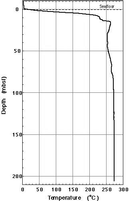 |
Figure 3. Temperature log from Hole 858G obtained with the Ultra High Temperature Multi Sensor Memory Tool (UHT MSM) from the University of Miami. The run was terminated within the casing at 206 mbsf after an obstruction was encountered. A very steep thermal gradient exists in the upper 10 m of the hole. The maximum observed temperature is 272°C at 98 mbsf and the conditions seem to be isothermal below this point. |
Bent Hill Site: Hole 856H
After drilling operations in Hole 856H were completed, the Triple Combo, composed of hostile-environment natural gamma ray (HNGS), dual induction resistivity (DIT), accelerator porosity (APS), and hostile-environment litho-density (HLDS) probes was deployed from 495 mbsf to the seafloor at 550 m/hr. This high speed was chosen to limit the exposure of the tool string to suspected high borehole temperatures. However, internal temperature readings of the tools indicated that the temperature was less than 100°C, and a high resolution repeat section was recorded at 250 m/hr from 365 to 85 mbsf. The caliper from the two passes confirmed that the hole was in a very good condition for an eventual Formation Micro Scanner (FMS) run
The FMS-Sonic combination composed of the formation micro-scanner (FMS), the array sonic tool (SDT) and the HNGS was deployed next to a depth of 491 mbsf. After approximately 60 meters of logging, the FMS readings began to deteriorate. Several unsuccessful attempts were made to improve the quality of the data while moving up the hole rapidly as it was feared that high temperatures were the origin of the problem. The only good quality FMS images from this run are in the deepest 60 meters of the hole, encompassing the pillow basalts and some of the sills recovered in the cores. During this run, good quality sonic velocities were recorded over the entire hole while going down, and over three different sections on the way up: 491-282 mbsf, 278-240 mbsf, and 225-109 mbsf.
A second attempt to run the FMS in the upper part of the open hole was made, owing to the importance of imaging the sulfide feeder zone for the objectives of the leg, and to the poor core recovery within this section. Cold seawater mixed with sepiolite was circulated for approximately an hour to recondition the hole, and the FMS alone was deployed. This run did not encounter any problems, and good quality data were recorded from 385 to 185 mbsf, and from 210 to 89 mbsf. External temperature showed that temperatures as high as 182°C had been reached, and it was decided not to attempt to run the Geochemical string, because of its sensitivity to elevated temperature.
Overall, the data recorded in Hole 856H are of good quality, and compare well to the discrete measurements made on core samples except for higher logging porosity measurements (Figure 4). Higher porosity readings recorded with the APS may have been caused by the presence of clay minerals because this tool sees all the hydrogen present in the formation, and cannot make the distinction between pore water and bound water, resulting in an apparent higher porosity.
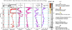 |
Figure 4. Downhole and discrete physical properties measurements from Hole 856H. Log units and stratigraphic units well as core recovery are also illustrated. Black symbols in porosity, density, and velocity curves represent shipboard laboratory measurements uncorrected for pressure and temperature effects. Discrepancies between laboratory and log measurements in the porosity curve are probably due to the presence of bound water within the claystones. |
Dead Dog Site: Hole 857D
After removing the data logger and thermistor string from Hole 857D, a temperature measurement using the Water Sampler Temperature Probe (WSTP) encountered an obstruction in the casing at 377 mbsf. Strong inflow of bottom water down the hole was indicated by an extrapolated equilibrium temperature of 2°C and by the seawater composition of the sample. A wiper trip was then made to clean the hole and to proceed resealing the hole with a new CORK and thermistor string. The impact of the apparent restimulation of downhole fluid flow on the Hole 858G records will be assessed at a later date.
The data logger had been previously damaged during Leg 146 as the crew attempted to replace the original thermistor string during bad weather conditions. Upon recovery, communications with the data logger could not be established and further attempts to retrieve the data and the logger from its bent casing were to deferred to the CORK group at Pacific Geoscience Centre (PGC) in British Columbia. At PGC, communications with the data logger were re-established and the pressure records showed a significant degree of underpressure below hydrostatic conditions after the sealed hole was close to reaching equilibrium conditions which also suggest the possibility of an inflow or recharge zone in this area (Earl Davis pers. comm., 1997).
Scientific Highlights
Bent Hill Sites
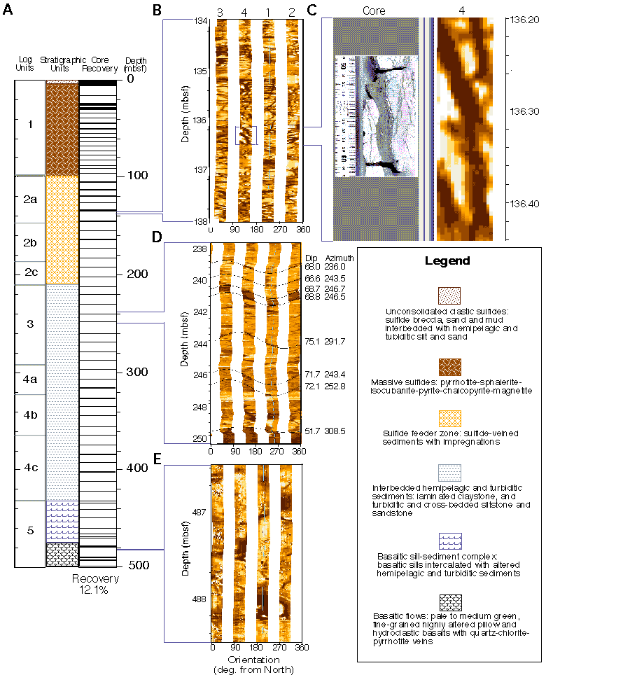
Due to the low core recovery in Hole 856H (Figure 5), data were of primary importance for the accurate delineation of the lithological units and structures identified from the core observations. Good hole conditions and significant variability in the composition and physical properties between the different types of formations allowed a clear identification of very distinct logging units and subunits (Figure 4). The main lithological units are recognizable on all the curves, but narrower intervals within these units also present distinctive features which allow a refinement of the stratigraphic boundaries.
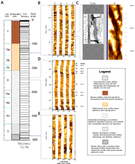 |
Figure 5. Results from ODP Hole 856H in the Bent Hill area of the Middle Valley, northern Juan de Fuca ridge. Core recovery, stratigraphic and log units (A), FMS and core images from the sulfide feeder zone (B & C), FMS images of fractures and possible fault within layered sediments (D), and the underlying pillow basalts (E). |
Logging Unit 1 (84.5 to 100 mbsf)
The position of the bottom of the pipe near the bottom of the massive sulfides precluded the acquisition of data in most of this section. However, this first logging unit, extending from the bottom of the pipe (84.5 mbsf) to about 100 mbsf, is characterized by the highest densities (4 g/cm?) and lowest resistivities recorded in Hole 856H. It corresponds to the massive pyrrhotite that forms the base of the sulfide mound, and which was partially logged during Leg 139 (Figure 4).
Logging Unit 2 (100 to 210 mbsf)
The second logging unit mostly corresponds to the sulfide feeder zone, or lithological Unit VI. Over this interval, three subunits were defined and all the logs display fluctuations related to the variations in the intensity of hydrothermal alteration and sulfide veining. From 100 to 145 mbsf (Subunit 2a), the resistivity reaches extremely high values, but generally tends to decrease with depth, as do the density and the velocity, whereas porosity reaches minimum values. This Subunit corresponds to sulfide veined sediments (Lithological Subunit VIa) at depths between 105 and 145 mbsf where core observations and FMS images also show that the formation is intensely, but unevenly, veined (Figure 4). High resistivity values in this unit are artifacts induced by the very high conductivity of the sulfides composing the veins, which is out of the standard range of operation of the DIT. As the sulfides become disseminated into siltstone beddings from 145 to 187 mbsf (Logging Subunit 2b), the resistivity and density curves remain relatively low, with local strong extrema, and the porosity fluctuates considerably around 50%. This Subunit corresponds to sediments with sulfide veins and impregnations (Lithologic Subunit VIb) located between 145 and 200 mbsf. High caliper readings show that this interval is the least mechanically consistent portion of the hole and might make the porosity measurements questionable. Between 187 and 210 mbsf (Subunit 2c), resistivity, density and sonic velocity again show significant variability influenced by high, but unevenly distributed sulfide content. Low gamma ray readings reflect the turbiditic nature of the sediments in this interval, which corresponds to sulfide banded sediments (Lithologic Subunit VIc). Over the entire Logging Unit 2, FMS images give a good picture of the vein network, and of its changes in density and general pattern with depth ().
Logging Unit 3 (210 to 292 mbsf)
Below 210 mbsf the sediments are only moderately altered and the logs become representative of the changes in structure and lithology through successions of interbedded mudstones, siltstones and sandstones. The distinction between the different units and subunits relies on the standard logs, but are also characterized in the FMS images by a high level of fracturing. These observations, combined with the occurrence of hydrothermal alteration in the rocks recovered over this interval (Core Sections 169-856H-33R-1 to 40R-1) could be an indication for a fault, which would also be consistent with the particularly poor recovery (on average 7.3%) over the entire unit. In particular, two intervals within this zone (221-239 mbsf and 250-270 mbsf) have low resistivity and very high porosity, features characteristic of fault zones or of fragmented formations (). The top of these two intervals at 221 and 250 mbsf, are marked by contact surfaces approximately dipping 50°W, while over the rest of the unit, the FMS shows a succession of fractures (239, 240, 241, 244, 246. and 290 mbsf) dipping in the same direction at angles ranging between 50 and 70 degrees (Figure 5D & ). Logging Unit 3 is interpreted as a fault zone constituted of two fractured intervals, which might be the extension through these relatively soft sediments of actual faults deeper in the basement, and of adjacent single fractures resulting from the same stress field, and acting as narrow fluid pathways. The sharp decrease in potassium above 292 mbsf (), and its almost complete disappearance above 270 mbsf, can be interpreted as the result of the leaching of the potassium during alteration due to the circulation of hydrothermal fluids within this fault zone.
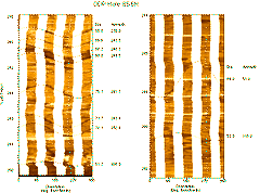 |
Figure 6. FMS images showing different types of fractures observed within Logging Unit 3 which is believed to be a fault zone. (A) Series of fractures dipping W-SW, at angles ranging from 66° to 75°. (B) Fractures in the deepest section of Logging Unit 3. The fracture at 290.5 mbsf, overlying fragmented material, could be interpreted as a pathway for hydrothermal circulation responsible for an observed decrease in potassium at this depth. |
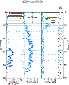 |
Figure 7. Potassium, uranium and thorium curves for Hole 856H. During Leg 169, the bottom of the drill string was positioned at 84.5 mbsf, and the data recorded above this depth is attenuated compared to the data from Leg 139 where the pipe was positioned at 20 mbsf. |
Logging Unit 4 (292 to 432 mbsf)
The top of this unit is marked by a sharp increase in gamma ray counts at 292 mbsf, which can be attributed to an increase in clay content and to the total absence of alteration by comparison to the overlaying unit (). Below this depth, Logging Unit 4 is composed of three subunits characterized by a progressive reduction in gamma ray counts, and by an increase in resistivity, density, and sonic velocity. From 292 to 323 mbsf (Subunit 4a), all the logs display almost constant values, and the FMS images show a succession of very fine beds dipping 2 to 10°S. These images also show fractures dipping in the opposite direction from the general pattern of the fault (at 298, 302, 304, 311 mbsf), which can be interpreted as conjugate fractures resulting from the same regional stresses that generated the fault. At 323 mbsf (top of Logging Subunit 4b), a discrete increase in density, resistivity and velocity, and a decrease in gamma ray indicate a higher proportion of sands. The FMS images show that the beds display similar dips and azimuth to those observed in Subunit 4a, but that the interbeds are thicker, which is also apparent in the reduction in frequency in gamma ray variations between the two subunits. Subunits 4a and 4b correspond to siltstone and sandstone lithofacies (core sections 169-856H-41R-1 to 47R-1), where the thickening of the sandstones beds with depth is also recorded. Below 365 mbsf (top of Subunit 4c), a similar discrete increase in density, resistivity and velocity is associated to a decrease in gamma ray and interpreted in the same manner as an increase in sand content ( figure 4). This interpretation contradicts the core analyses of the formation which describe this interval as being mainly composed of mudstone and siltstone lithofacies. However, the poor core recovery (less than 10 % on average) throughout this interval could be the origin of the differences between the core and log interpretations. No FMS data were recorded over this subunit, but the reduction in the frequency of the Gamma Ray variations suggests a thickening of the interbeds from Subunit 4b to Subunit 4c.
This unit encompasses Lithologic Units VII and VIII and is indicated by the first occurrence of igneous rocks. A distinctive log response to igneous units is a very strong increase in density, sonic velocity and resistivity, and proportionate drops in porosity and gamma ray ( figure 4). The shallowest igneous intrusion could not be imaged because of the failure of the FMS shortly after the beginning of its first deployment, but the other logs show that this sill has a thickness of approximately four meters. Three other igneous units produce the same characteristic changes in the different logs (), and can also be clearly identified on the FMS images: two narrow sills, from 447 to 449 mbsf, from 456 to 458 mbsf, and a thicker unit from 464 to 468 mbsf. A close observation of the FMS images suggests that this unit might be actually composed of flows, but this could not be confirmed from core observation, since the recovery was particularly poor in the deepest section of the hole. Below this depth, the quality of the logs is poor, because of the length of the tool strings, and because of a failure of the telemetry when the caliper arm of the Triple Combo was open. The deepest images recorded by the FMS seem to identify pillow basalts in several locations, most clearly from 471 to 473 mbsf and below 485 mbsf ( figure 5e), which would corroborate the observation of highly altered hyaloclastic materials on some samples which are interpreted as old glassy pillow margins (cores 169-856H-63R and 64R).
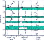 |
Figure 8. Different igneous units encountered at the bottom of Hole 856H. These units are characterized by low gamma ray and high resistivity and density measurements. FMS images and core observations suggest that the deepest unit is constituted of extrusive pillow lavas (Figure 5E) whereas the three shallower are basaltic sills. |
Additional Temperature Measurements
The deployment of the ADARA and WSTP tools provided an insight into the subsurface temperature distribution within the Bent Hill area. A total of eight discrete temperature measurements in four holes were taken with these tools at various steps of the drilling at Sites 1035 and 856. The data recorded in Holes 1035A, D and E show temperature gradients ranging from 1.24 to 2.18°C/m, in agreement with the values recorded during a previous surveys.
Escanaba Trough of the Southern Gorda Ridge
Operations Summary
Reference Site: Hole 1037B
A wiper trip was done after coring operations were completed in Hole 1037B to clear any potential ledges and to clean 35 m of fill from the bottom of the hole at 546 mbsf. At the conclusion of the hole conditioning process, the RCB bit was dropped at the bottom of the hole, the pipe was set at 100 mbsf, and the Triple Combo was deployed. The Triple Combo, composed of temperature (TLT), DIT, HLDS, APS, and HNGS probes, encountered several difficulties during the run. The DIT failed to transmit a signal shortly after entering the open hole and several attempts to reestablish communications were not successful. The run was continued to the bottom of the hole without resistivity measurements to determine hole conditions with the caliper from the HLDS. The caliper showed that the hole diameter was larger than the maximum aperture of the FMS (15 in) for most of the hole and it was decided to replace the FMS with a spare DIT for the second run. This decision was based on the fact that the caliper arms of the FMS have a maximum aperture of 15 inches and under these conditions, the resistivity data would produce better results. A repeat section with the Triple Combo was aborted when the caliper arm apparently failed to close when entering the pipe at 100 mbsf. The second run, composed SDT, DIT, and natural gamma-ray (NGT) probes, reached the bottom of the hole at 535 mbsf without any problems.
The quality of the data recorded in this hole varies due to poor hole conditions. The gamma ray and resistivity curves seem to be of good quality because of their deep focus of investigation. The density, porosity, and velocity logs are strongly affected by borehole wall irregularities as shown by the extremely low density and velocity values as well as high porosities throughout most of the hole.
 9A |
 9B |
 9C
|
 9D |
|
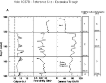
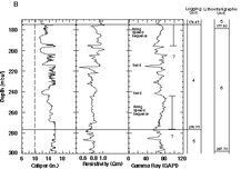
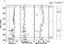
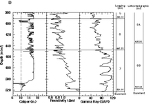
Figure 9. Caliper, resistivity, and gamma-ray downhole measurements recorded during Leg 169 in sections of Hole 1037B from (A) 100 to 180 mbsf, (B) 170 to 300 mbsf, (C) 270 to 400 mbsf, and (D) 380 to 530 mbsf. Logging units and their respective depths as well as stratigraphic units and features identified from logs and recovered cores are also shown. Question marks represent discrepancies between core observations and log measurements probably due to poor recovery and hole conditions.
|
|
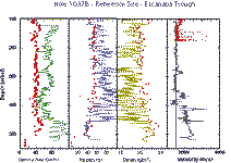 |
Figure 10. Comparison of downhole measurements and physical properties data (red dots). Index properties porosity and density data, Multi Sensor Split Core Liner track (MSSCL) velocity data, and Multi Sensor Track (MST) gamma-ray data were used for the correlations. The solid line on the velocity profile denotes the approximate velocity of seawater. |
Scientific Highlights
Reference Site: Hole 1037B
The high recovery in Hole 1037B provided the opportunity to perform accurate core to log correlations and precisely delineate numerous sedimentary sequences identified from core observations. Because of large variations in borehole diameter, the gamma ray and resistivity curves proved most useful in the identification of seven main logging units within the Pleistocene stratigraphic sequence. The main lithological units are recognizable on both the gamma ray and resistivity curves, with the gamma ray log showing a good correlation with downhole grain size variations but stratigraphic boundaries do not precisely coincide with all the logging unit boundaries. Descriptions of logging units and correlations with lithostratigraphy are discussed below.
Logging Unit 1 (102 to 121.90 mbsf)
The lower most 20 m in lithostratigraphic Unit 3 were imaged owing to the position of the pipe near the bottom of the unit (). Low gamma ray counts and higher resitivities clearly reflect the sandy nature of the basal part of this unit. The contact between logging Units 1 and 2 correlates well with core observations and can be clearly identified by an increase in gamma ray counts and a decrease in resistivity, indicating a sharp transition into a more clay-rich formation.
Logging Unit 2 (121.90 to 153.90 mbsf)
The second logging unit is more complex in nature and its base (153.90 mbsf) does not coincide with the bottom of lithostratigraphic Unit 4 (142.85 mbsf). The logging unit is characterized by the gamma-ray and resistivity curves responding in a manor suggestive of a series of alternating clay and muddy sand beds with the basal contact defined by what seems to be a fining-upward sequence (). Four units interpreted as muddy sands range in thickness from approximately 2 to 5 m whereas the thickness of the clay-rich units ranges from 2 to 6 m.
Logging Unit 3 (153.90 to 174.45 mbsf)
This logging unit is defined by the termination of an apparent fining-upward sequence hence, its top does not correspond to the top of lithostratigraphic Unit 5 (142.85 mbsf). A reduction in gamma ray and an increase in resistivity is consistent with an increase in sand content up to the contact with logging Unit 4, which coincides with the top of lithostratigraphic Unit 6.
Logging Unit 4 (174.45 to 276.75 mbsf)
The top and bottom of this logging unit are defined by log responses indicative of fining-upward sequences (), with the base approximately 20 m shallower than the base of lithostratigraphic Unit 6 (297.70 mbsf). Most of this logging unit is interpreted to be clay-rich beds with some minor but distinctive low gamma ray layers which correlate well with sandy units recovered from the main section of lithostratigraphic Unit 6. An exception is the log section denoted with a question mark on Figure 9B at approximately 203 mbsf. The transition from what is interpreted as a sandy layer to a more clay-rich zone at this depth was not documented in core observations. Possible explanations for the discrepancy include the lack of recovery in this particular interval and the location of this logging unit within an irregular section of the borehole.
Logging Unit 5 (276.75 to 390.10 mbsf)
The top of this unit is marked by the base of a fining-upward sequence approximately 20 m shallower than the top of lithostratigraphic Unit 7. The upper section of this logging unit correspond to a 60 m thick predominantly clay-rich section whereas the bottom most 52 m show low gamma ray counts indicative of a sand-rich section.
Logging Unit 6 (390.10 to 447.55 mbsf)
The top and bottom of this logging unit are interpreted to be comprised mostly of clay-rich beds interbedded with thinner sandy units and correlates well with the top of lithostratigraphic Unit 8A. The contact with logging Unit 5 is marked by a sharp transition shown by an increase in gamma ray counts and a decrease in resistivity interpreted to reflect a more clay-rich zone.
Logging Unit 7 (447.55 to 521.05 mbsf)
This logging unit is characterized by a gradual increase in resistivity and higher gamma readings than the values observed for logging Unit 6. This logging unit correlates with lithostratigraphic Unit 8B and suggests that this poorly recovered interval is composed of well defined sand and clay-rich beds. The gradual increase in resistivity may be an indication of an increase in calcareous cementation and induration of the rocks recovered from this section. The bottom of this unit is marked by a high resistivity jump at 518 mbsf which correlates with the top of the igneous basement observed in the cores.
Porosity, density, and velocity logs for the most part show the effects of the large diameter of the borehole. The lowest recorded porosities and the highest densities correlate well with physical properties measurements. However, it is difficult to detect any particular trends from these logs except over a 40 m section between 240 to 280 mbsf, and the bottom most section of the hole. The upper 40 m interval corresponds to a smaller diameter section of the hole within a fining-upward sequence in logging Unit 4, whereas the bottom 70 m of logged hole has lower porosities (~ 35%) and higher densities (~ 2.15 g/cm3) which may reflect increases in the degree of induration and the increase in carbonate cementation. Sonic velocity values above 2000 m/s at 400 mbsf may also indicate an increase in induration with depth.
The most significant variations in potassium, uranium, and thorium values are in logging Units 2, 5, 6, and 7. Recovered cores throughout this interval suggest that increases in all three elements in logging Unit 2 are most likely due to high clay contents. The variations in logging Unit 5 can also be correlated to the clay composition of the upper part of the section and the sandier nature of the bottom of this interval. Lower density and higher porosity trends corresponding to the sandy portion of the interval covered by logging Unit 5 are observed in the noisy porosity and density logs, suggesting that this interval is less indurated. The interval may be permeable, thus fluid flow through the formation may deplete the formation of these three radioactive elements. There is a gradual increase in K, U and Th starting at the top of logging Unit 6, with the most significant increase occurring at the top of logging Unit 7. The sharp increase in all three radioactive elements correlates with increases in potassium, strontium, rubidium, and lithium contents of the pore waters, and may indicate fluid flow from the potassium-rich basaltic basement.
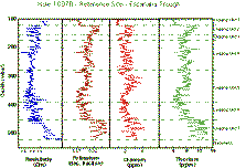 |
Figure 11. Downhole measurements showing vaiations in relative abundances for radioactive elements K, U, and Th. In addition, a resistivity curve is included for correlation purposes and depths of logging units are also shown.r |
Borehole temperatures were measured with the LDEO temperature tool (TLT) at the bottom of the Triple Combo tool string. Both downgoing and upgoing borehole temperature profiles were recorded during this run (). A difference of 10°C between the profiles at the bottom may represent the extent of thermal rebound at this time in the operations, but could also be attributed to the removal of cold mud accumulated around the sensor on the way down. The downgoing profile also shows several sharp variations in temperature as ledges were encountered at the bottom of the hole. This variations may represent frictional heating as the probe penetrated muddy formations. This explanation seems reasonable since mudcakes were retrieved from the probe's tip upon recovery, but it may only account for some of the differences in temperatures between the profiles. However, neither of these two profiles can be considered as representative of the actual borehole temperature distribution because of the long lasting effects caused by drilling disturbances. The temperature difference between the profiles at 100 mbsf is approximately 3°C.
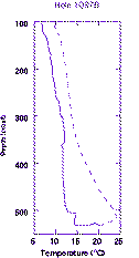 |
Figure 12. Borehole temperatures recorded with the Lamont-Doherty temperature tool approximately 6 hours after coring operations were completed. The solid line represents the downhole profile and the dashed line corresponds to the uphole profile. |
The deployment of the ADARA temperature tool provided an insight into the subsurface temperature distribution within the reference site area of the Escanaba Trough. A total of four formation temperature measurements were taken with this tool at the top of the hole during coring operations however, borehole instabilities precluded the use of this tool beyond 85.5 mbsf. Analysis and interpretation of the temperature records allowed calculations of a linear thermal gradients which give a temperature of approximately 87°C at the bottom of the hole. This value is consistent with temperature projections for the sediment-basalt interface calculated from previous surface heat flow surveys.
References
Davis, E. E., Becker, K., Pettigrew, T., Carson, B., and MacDonald, R., 1992. CORK:
A hydrological seal and downhole observatory for deep-ocean boreholes. In Davis, E. E., Mottl, M. J., Fisher, A. T., et al., 1992. Proc. ODP, Init. Repts., 139: College Station, TX (Ocean Drilling Program), 43-53 .
Davis, E. E., Mottl, M. J., Fisher, A. T., et al., 1992. Proc. ODP, Init. Repts., 139:
College Station, TX (Ocean Drilling Program).
Proceedings of the Ocean Drilling Program, Initial Reports
Proceedings of the Ocean Drilling Program, Scientific Results
| Robert Gable Downhole Logging Bureau de Recherches Géologiques et Miniéres R.Gable@BRGM.Fr |
Henrike Gröschel-Becker Downhole Logging Rosenstiel School of Marine and Atmospheric Sciences University of Miami Division of Marine Geology and Geophysics Henny@RCF.RSMAS.Miami.Edu |
| Gilles Guerin Downhole Logging Lamont-Doherty Earth Observatory Columbia University Borehole Research Group Guerin@LDEO.Columbia.Edu |
Gerardo J. Iturrino Downhole Logging Lamont-Doherty Earth Observatory Columbia University Borehole Research Group Iturrino@LDEO.Columbia.Edu |
| Yves Fouquet IFREMER Centre de Brest DRO/GM BP 70 29280 Plozane, France Fouquet@IFREMER.Fr (33) 98-22-42-54 |
Robert A. Zierenberg Department of Geology USGS Branch of Western Mineral Resources University of California - Davis Davis, California 95616 Zierenberg@Geology.UDavis.Edu (916) 752-1863 |
| Jay Miller Ocean Drilling Program Texas A? Research Park 1000 Discovery Drive College Station, Texas 77845 Jay_Miller@ODP.TAMU.Edu (409) 845-2197 |
| Jean M. Bahr Physical Properties University of Wisconsin - Madison JMBahr@Geology.Wisc.Edu |
Paul A. Baker Sedimentology Duke University PBaker@Geo.Duke.Edu |
| Terje Bjerkgården Petrology Norges Geologiske Undersøkelse Terje.Bjerkgard@NGU.No |
Charlotte A. Brunner Paleontology University of Southern Mississippi CBrunner@Whale.St.USM.Edu |
| Rowena C. Duckworth Petrology James Cook University of North Queensland Rowena.Duckworth@JCU.Edu.Au |
Joris Gieskes Inorganic Geochemistry Scripps Institution of Oceanography JGieskes@UCSD.Edu |
| Wayne D. Goodfellow Petrology Geological Survey of Canada Goodfellow@GSC.Nrcan.Gc.Ca |
Jun-ichiro Ishibashi Inorganic Geochemistry University of Tokyo Ishi@Eqchem.S.U-Tokyo.Ac.Jp |
| Rachael H. James Sedimentology/Geochemistry University of Bristol R.H.James@Bris.Ac.UK |
Klas S. Lackschewitz Sedimentology Christian-Albrechts-Universität Kiel KLackschewitz@GPI.Uni-Kiel.De |
| Lynn Marquez Structural Geology Northwestern University Marquez@Earth.NWU.Edu |
Pierre Nehlig Structural Geology Bureau de Recherches Géologiques et Miniéres P.Nehlig@BRGM.Fr |
| Jan M. Peter Petrology Geological Survey of Canada JPeter@NRCan.Gc.Ca |
Catherine A. Rigsby Sedimentology East Carolina University g1Rigsby@Ecuvm.Cis.ECU.Edu |
| Peter Schultheiss Physical Properties GEOTEK, Ltd. Gjh@GEOTEK.Co.UK |
Wayne C. Shanks, III Petrology United States Geological Survey PShanks@Helios.Cr.USGS.Gov |
| Bernd R.T. Simoneit Inorganic Geochemistry Oregon State University Bmcvicar@Oce.ORST.Edu |
Melanie Summit Microbiology University of Washington Summit@Ocean.Washington.Edu |
| Damon A.H. Teagle Petrology University of Michigan Teagle@UMich.Edu |
Michael Urbat Paleomagnetics Utrecht University Urbat@Geof.Ruu.Nl |
| Gian G. Zuffa Sedimentology Università di Bologna Zuffa@Geomin.Unibo.It |
Back to Logging Summaries