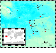
The Paleogene Equatorial transect (ODP Sites 1215 to 1222, Fig. 1) aimed to study the evolution of the equatorial Pacific current and wind system as the Earth went from maximum Cenozoic warmth to initial Antarctic glaciations. Along 56- to 57-Ma crust, it extends from a paleolatitude of about 11oN to about 5oS and encompasses anomalously thick early Eocene sediments deposited as much as 8o north of the Paleocene equator.
Figure 1: Location map of the Paleogene Equatorial transect and Leg 199 drilled sites. Logged sites (1218 and 1219) are marked by a star.
The transect collected continuous sediment sequences to document the evolution of the equatorial current system, equatorial surface-water and deep-water temperature variations, wind patterns, and productivity in the late Paleocene and early Eocene. In addition, Site 1218 has also been drilled on 40 Ma crust to collect a near-equatorial sediment sequence from the middle Eocene through the late Eocene transition to glacial conditions in Antarctica. If the plate tectonic model used for paleopositions is approximately correct, Site 1218 is at the equator at 40 Ma. This latter site has been specifically drilled to study the changes in equatorial circulation associated with the transition from the late Eocene to the early Oligocene ice-house world (Fig 2).
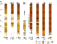
Figure 2: Lithologic columns for sites drilled on ODP Leg 199. At Site 1215, Unit 3 (metalliferous ooze) is not plotted. At Site 1217, the basalt-nannofossil chalk is not yet accurately placed.
The objectives of Leg 199 were.
1. Collection of continuous sequences of Paleogene sediment to improve Paleogene biostratigraphy and to tie this stratigraphy to paleomagnetic chronostratigraphy;
2. Better constraint on the late Paleocene and early Eocene equatorial position using paleomagnetic and micropaleontologic indicators;
3. Link seismic stratigraphy from the site survey to sediment chronostratigraphy extending the Neogene equatorial Pacific seismic stratigraphy (Mayer et al., 1985, 1986; Bloomer et al., 1995) farther back in time;
4. Locate the transition between Asian and American dust sources to understand the primary structure of the Paleogene wind field;
5. Provide primary geochemical information needed to understand the widespread formation of Eocene cherts;
6. Provide important data to make an early Paleogene mass balance of carbonate and opal burial and to track the Eocene movement of the carbonate compensation depth (CCD) in detail; and
7. Collect basal hydrothermal sediment sections for the study of hydrothermal activity in the early Paleogene.
Because logging measurements are at an intermediate scale between cores and geophysical surveys, core-log / log-seismic integration provide a unique method for extrapolating borehole data to a regional scale (Fig. 3).
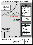
Figure 3: Schematic displaying the contribution of logging. (1) core-log integration: logs provide true depth to adjust core-derived measured composite depth (mcd), and (2) log-seismic integration allowing identification and dating of seismic reflectors.
The main contribution of acquisition of in situ, continuous multi-parameter logging data
are:
(1) assess the physical, chemical and structural characteristics of the formation, and to provide the baseline for depth matching the core-derived composite depth (mcd) scale.
(2) perform cyclostratigraphic analysis of continuous Paleogene sequences.
(3) identify and characterize chert layers which are poorly recovered in cores.
(4) conduct a seismic integration (time/depth model and synthetic seismogram) allowing identification and dating of seismic reflectors at a regional scale.
Two sites (1218 and 1219) were successfully logged using the Geophysical Triple-Combo/MGT and FMS-sonic toolstrings. Each toolstring reached the bottom of the hole on all passes (Fig. 4).

Figure 4: Summary of the logging operations undertaken at Holes 1218A and 1219A
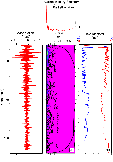
For both sites, data are displayed in figures 5 and 6, respectively. The data are available from the ODP Logging Services Database, although access will remain under moratorium until December 2002. Further information about the logging tools and technical background can be found in the Tools section of the ODP Guide to Logging.
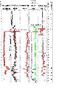
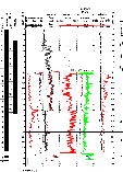
Figure 6: Core recovery, geophysical toolstring logs (Triple Combo) and core data for Hole 1219A. The high-resolution output from a single FMS button is also included.
Assessment of logging data quality is a key-step before core-log and log-seismic integration. Logging data are commonly sensitive to ship heave motion and borehole condition (hole diameter and rugosity). In the case of soft and slow formations, such as those encountered during this Leg, special attention must be paid to velocity measurements.
Localization in depth of the measurement requires logging at a constant speed (zero acceleration). Departure from zero acceleration may impair data quality. During logging operations, heave conditions were good (< 2m). Accelerations recorded in the various toolstring do not exceed 1m/s2, values commonly observed in oceanic logging. In order to identify in depth the frequency components of the recorded accelerations, depth-frequency signal analysis based on the continuous wavelet transform method has been applied.
Continuous wavelet analysis provides an automatic localization of specific behavior, such as cyclic patterns or discontinuities, both in time and frequency (e.g., Torrence and Compo, 1998). In contrast to classical Fourier Transform (FT) or Windowed Fourier Transform (WFT) which decompose the original signal on the basis of an infinite periodic function, depending on a unique parameter (space frequency), the wavelet transform (WT) allows a "depth-scale" representation that depends on a scale parameter and a translation parameter. Figure 7 presents the analysis from one pass each of the MGT and FMS-Sonic logging runs (Hole 1219A). The MGT pass displays a very smooth wavelet spectrum with the only significant frequency band operating at a depth-scale of <1.6 m (Fig. 7a). This frequency band relates to the heave motion of the ship (despite the damping effect of the WHC). Thus, for the MGT passes the data quality can be assumed to be excellent. The wavelet spectrum from pass 2 of the FMS-Sonic toolstring is shown in Figure 7bii. Visually the acceleration data is more complex and this is interpreted to reflect the greater degree of contact between the FMS-Sonic toolstring and the borehole walls, than is the case for the Triple Combo. The four FMS pads and two centralizers for the DSI contact the borehole walls making for greater frictional resistance during logging, compared to the MGT which only has one bow spring. The wavelet spectrum shows the same high frequency heave component but also three lower frequency bands operating at depth scales of around 4.5 m, 15 m and 25 m, seen in the Blackman Tukey Spectrum (Fig. 7bi). The 25 m frequency is present downhole to a depth of approximately 200 mbsf, while the two shorter frequency bands only appear above 150 mbsf (i.e., in the carbonates). The accelerometer data from the FMS-Sonic tool indicates good quality data, with the longer frequency depth-scale cycles being interpreted to represent formation related parameters (see Fig. 6).
Borehole width and wall rugosity may also affect the quality of data from tools that require good tool-borehole wall contact (e.g., the HLDT density tool). The Triple Combo caliper indicates that top of borehole 1219A is especially rugose. The quality of these data was checked using the wavelet transform. In Figure 8 the high frequency range of the wavelet spectrum of both the density (Fig. 8a) and the borehole wall (Fig 8c) is shown. The density (Fig. 8b) displays no significant cyclicity in the formation below 150 mbsf, but above (in the carbonates) shows some cyclicity at a depth-scale of about 8 m. The borehole-wall wavelet spectrum (d) has no significant cyclicity operating at high frequency, where borehole wall rugosity effects would be expected to be greatest. The cross-wavelet modulus spectrum (Fig. 8e) shows no significant high frequency interactions between density and borehole diameter. The phase diagram (fig. 8e) perhaps sums up the data quality best. If data quality was being impaired, it would be expected that, as the borehole wall widened, the density would decrease (i.e., greater influence of mud density) and the signals should be out of phase. However, the high-frequency spectrum shows that the borehole wall and density data are in phase indicating no degradation of the data. A similar analysis could be undertaken for the porosity data, but the relationship is not so simple (i.e., in either situation, degraded or not-degraded, the two signals should be in-phase). However, given that the resolution of the porosity tool is less than the (unaffected) density tool and the good correlations shown between the porosity log and core porosity, the porosity log is believed to be of excellent quality (Fig. 6).
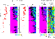
Figure 8: Quality control analyses of the density data (a) in relation to possible borehole wall rugosity effects (c) from Triple Combo pass 1. Respective wavelet spectrum diagrams are shown for density (b) and borehole diameter (d) (Hole 1219A). The cross-wavelet spectrum is presented in the modulus (e) and phase (f) diagrams. Note the high significance region in the density wavelet spectrum at about 100 mbsf (b), which is produced by the density spike at the same depth (a).
The sonic velocity data in formations such as those logged at this site are invariably difficult to interpret because the velocity of the drilling mud is so close to that of the formation and also the slowness of the formation reduces the quality of the return signal to the receivers. The P-wave processing algorithm for the DSI tool, used at Site 1218, has difficulty in resolving the P-wave of the formation from the fluid wave of the drilling mud, leading to velocity data sets which are incomplete (Fig. 5). As an experiment, at Site 1219 an additional data collection mode, FMD, was run. The wave-labelling algorithm this time used the first good signal it receives and assumes this to be the formation P-wave. The results of this experiment are presented in Figure 9 and compare favorably with the core data. The FMS-Sonic velocity data are shown along with the coherency plots of the stacked sonic waveforms, with the dashed lines representing algorithm labelled waves (P-wave and S-wave). Plotting the data as shown in Figure 9 provides a method for qualitatively assessing the data quality. The FMD data looks good for the most part, except between 153 mbsf and 168 mbsf, where the coherency band is very narrow indicating either, mud velocity or, equal mud/formation velocities. However, when compared to the density data (Fig. 6) and the core velocity data the FMD data appears good. The use of the FMD mode in conjunction with the P and S monopole mode may prove to be a useful addition to the velocity measurements routinely made during ODP logging when investigating slow formations.

Figure 9: Example of the problem encountered by the P-wave labelling algorithm, in Îslowâ sediments, where the formation velocity approaches those of the drilling mud, taken from the coherency plot of FMS-Sonic pass 1 (Hole 1219A). The dashed lines represent the results of the wave labelling algorithms.
With respect to the leg objectives (see above) the results are as follows:
(1) to assess the physical, chemical and structural characteristics of the formation, and to provide the baseline for depth matching the core-derived composite depth (mcd) scale. Formation properties correlated well with the lithostratigraphy and excellent pattern matching between the core and the log data was achieved (Figures 5 and 6). Thus the core-derived measured composite depth (mcd) can be accurately adjusted to the true depth.
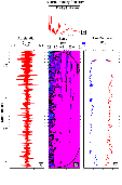
(2) to perform cyclostratigraphic analysis of continuous Paleogene sequences. A number of high-resolution data sets were recorded including gamma ray measurements from the Lamont-Doherty Multi-Sensor Gamma Ray Tool (MGT). The Formation MicroScanner (FMS) micro-resistivity data imagery identified cycles operating at the sub-meter level and the raw button information will provide a data set readily amenable to time series analysis (Figure 10).
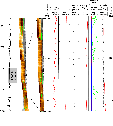
Figure 10: FMS (single button micro-resistivity plot and dynamic normalized image), geophysical and geochemical log data for a section in Log Unit 1 (Hole 1218A). The high-resolution gamma ray log identifies 0.5-1 m cyclicity, while the higher resolution FMS image data also identify the higher frequency cycles.
(3) to identify and characterize chert layers which are poorly recovered in cores. The excellent quality FMS imagery obtained on both passes with this toolstring provided clear information on the location, number and thickness of the chert layers (Figure 11).
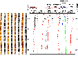
Figure 11: Chert bands in Log Unit 2 (Hole 1218A), responsible for the resistivity and density log peaks are easily recognizable in the FMS image as the high resistivity (light) areas. A trace from an FMS button is included to show the raw data.
(4) to conduct a seismic integration (time/depth model and synthetic seismogram) allowing identification and dating of seismic reflectors at a regional scale. Core and log data have been spliced to provide density and velocity logs used to produce synthetic seismograms. Good matching between the synthetic and the seismic data sets has been achieved, allowing the seismic stratigraphy to be correlated with the lithostratigraphy (Figs 12). Correction factors for the core to in situ data sets will be used for the non-logged sites to produce a regional suite of synthetics, providing the basis for a regional seismic stratigraphy, a key parameter in reconstructing the paleoceanography of the Equatorial Pacific through the Paleogene.
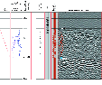
Figure 12: Synthetic seismogram derived from the PWL velocity measurements and density (spliced log and corrected GRA core) data for Hole 1219A. Note the location of the bottom of the hole on top of the first strong (chert?) reflector. The depth vs. time relationship, density and velocity curves and reflection coefficients are also shown.
Bloomer, S.F., Mayer, L.A., and Moore, T.C., 1995. Seismic stratigraphy of the eastern equatorial Pacific Ocean: paleoceanographic implications. In Pisias, N.G., Mayer, L.A., Janecek, T.R., Palmer,-Julson, A., and van Andel, T.H. (Eds.), Proc. ODP, Sci. Results, 138: College Station, TX (Ocean Drilling Program), 537-553.
Mayer, L.A., Shipley, T.H., Theyer, F., Wilkens, R.H., and Winterer, E.L., 1985. Seismic modeling and paleoceanography at Deep Sea Drilling Project Site 574. In Mayer, L., Theyer, F., Thomas, E., et al., Init. Repts DSDP 85: Washington, (U.S. Govt. Printing Office), 947-970.
Mayer, L.A., Shipley, T.H., Winterer, E.L., 1986. Equatorial Pacific seismic reflectors as indicatorsof global oceanographic events. Science, 233:761-764.
Torrence, C., and G. Compo (1998). A practical guide to wavelet analysis, Bull. Amer. Meteor. Soc., 79, 61-78.
Philippe Gaillot: Logging Staff Scientist, Universite Montpellier II
Laboratoire de Mesures en Forages, ISTEEM cc 049, Place Eugene Bataillon,
Montpellier Cedex 5, 34095,France. email: gaillot@dstu.univ-montp2.fr
Brice Rea: Trainee Logging Staff Scientist, Department of Geology, University of Leicester, University Road, Leicester, UK. email: brr2@leicester.ac.uk
(page will open in a new window)
Proceedings of the Ocean Drilling Program, Initial Reports
Proceedings of the Ocean Drilling Program, Scientific Results