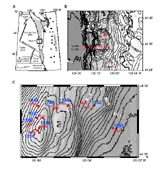
Figure 1. Map showing the location of Sites 1244-1252, drilled during Leg 204 on Hydrate Ridge.
Downhole Logging Summary
Introduction
During Ocean Drilling Program (ODP) Leg 204, a total of nine sites, 1244-1252 (Figure 1), were drilled through the gas hydrate stability zone on the southern part of Hydrate Ridge on the Cascadia accretionary margin, offshore Oregon. The main objectives of the leg were to (1) compare the source region for gas and the mechanisms of hydrate formation between the accretionary ridge and adjacent slope basin settings; (2) calibrate estimates of hydrate and underlying free gas concentrations using geophysical remote sensing techniques; (3) test whether variations in bottom-simulating reflector (BSR) and sub-BSR reflectivity observed in seismic data result from tectonically induced hydrate destabilization; (4) identify paleoproxies for methane release that can be used to integrate the geologic data into climate models; (5) evaluate the relationship between hydrates, fluid flow, and slope stability; and (6) quantify the distribution of methanogenic and methanotropic bacteria in the sediments and evaluate their contribution to hydrate formation and destruction and related sediment diagenesis.
Figure 1. Map showing the location of Sites 1244-1252, drilled during Leg 204 on Hydrate Ridge.
For further information regarding gas hydrates and the background geological setting see the Leg 204 Initial Report. The first part of Leg 204 was dedicated entirely to logging while drilling (LWD) to identify potential gas hydrate bearing intervals prior to coring. The data were of excellent quality, thus allowing optimization of the use of time-consuming special tools to measure in situ temperature and pressure and to retrieve cores at in situ pressure. The leg also included an extensive wireline logging program and a two-ship seismic program with the R/V Maurice Ewing to acquire offset and walkaway vertical seismic profiles (VSP). The log data are available from the ODP Logging Services database.
Logging Tools
The downhole logging program on Leg 204 was specifically designed to obtain the data needed to assess the occurrence and concentration of gas hydrates on Hydrate Ridge. Logging while drilling (LWD), measurement while drilling (MWD) and/or wireline logging tools (Figure 2. A and B) were deployed at all of the sites drilled on southern Hydrate Ridge. LWD tools measure in-situ formation properties with instruments that are located in the drill collars immediately above the drill bit. The measurements are made shortly after the hole is drilled and before the adverse effects of continued drilling or coring operations. MWD tools are also located in the drill collars and measure downhole drilling parameters (e.g., weight on bit, torque, etc.). LWD data are recorded into downhole computer memory and retrieved when the tools reach the surface, whereas MWD data are transmitted through the drilling fluid within the drill pipe by means of a modulated pressure wave, or "mud pulsing", and are monitored in real time. The MWD tools enable both LWD and MWD data to be transmitted uphole when the tools are deployed together.
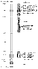
Figure 2. A, Configuration of LWD tools used during Leg 204; B, Configuration of wireline tool strings used during Leg 204; and C, the RAB coring tool used for the first time during Leg 204.
The GeoVision Resistivity (GVR) tool (Figure 2A), the most recent upgrade of the RAB tool provides shallow-, medium-, and deep-focused resistivity measurements of the formation and azimuthally oriented electrical images of the borehole wall. The images are similar to those obtained by the Formation MicroScanner but with complete coverage of the borehole walls and slightly lower vertical and horizontal resolution. The U.S. Department of Energy provided funding support to deploy Anadrill's Nuclear Magnetic Resonance While Drilling (MRWD) tool (Figure 2A).The basic technology behind this tool is similar to modern wireline nuclear magnetic resonance technology (e.g., Horkowitz et al., 2002). The Vision Density Neutron (VDN) tool (Figure 2A) is similar in principle to the Azimuthal density neutron (ADN) tool (Anadrill-Schlumberger, 1993) and provides a borehole-compensated density measurement, a photoelectric effect value, and a neutron porosity measurement.
Both the standard wireline toolstrings, the Triple Combo and the FMS-Sonic were deployed at six of the drilled sites (Figure 2B). The triple combo string consists of the hostile environment spectral gamma ray sonde (HNGS), the phasor dual induction and spherically focused resistivity tool (DITE-SFR), the hostile environment lithodensity tool (HLDT), and the accelerator porosity sonde (APS). The LDEO high-resolution temperature-acceleration-pressure tool (TAP) was attached at the bottom of this tool string. The FMS-Sonic tool string consists of the Formation MicroScanner (FMS), a general purpose inclinometer tool (GPIT), a scintillation gamma ray tool (SGT), and the dipole shear sonic imager tool (DSI). An in-line Quick Shot Seismic Tool (QSST) was included for the first time this leg, with the triple combo string (Figure 2B). In addition, seismic tools including the vertical seismic imager tool (VSI), a specialty tool used for the first time on an ODP leg, the well seismic tool (WST) and the 3 component well seismic tool (WST-3) were deployed at five of the sites that were wireline logged.
The RAB-8 was run with a modified tool collar configuration and a modified MDCB core liner system, allowing to make RAB measurements while coring. The US Department of Energy provided partial funding support for these modifications specially designed for ODP, for use with a larger 8-inch-diameter BHA (Figure 2C). It was the first ever attempt in the history of ODP to core and record LWD data simultaneously. For a fuller description of the tools deployed during Leg 204 consult the Leg 204 Initial Reports Volume and the ODP Logging Services web site, and for a description of their applications see Rider (1996) and Schlumberger (1989).
Logging Operations
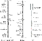
A total of sixteen holes were logged during Leg 204, ten LWD holes and six wireline holes (see Table 1). Logging operations for the most part were highly successful. LWD proceeded at approximately 25 m/hr (Figure 3. A and B ) at most sites to the total depth (see Table 1) without difficulty and real time data were transmitted to the surface at a rate of 6 Hz. Because of a tool failure in Hole 1250A, a second LWD hole (1250B) was drilled in Site 1250 (Figure 3C). In holes 1250B and 1251A the rate of penetration (ROP) was increased to a relatively high rate of 50 m/hr at around 25 mbsf and maintained to the total depth in an attempt to speed up operations after the time lost on Hole 1250A. The increase in ROP did not significantly degrade the quality of the data. The RAB-8 tool was deployed in Hole 1249B and drilling proceeded ahead to 30 mbsf, where RAB coring operations began, using 4.5-m-long core liners through the shallow gas-hydrate-bearing sedimentary sequence. After the six core liners had been used, two 9-m-long cores were cut without liners to 75 mbsf. Bit rotation varied from 15-45 RPM, increasing with depth, and the average penetration rate using this system was around 8 m/hr.
| ODP Site & Hole | Water Depth (mbrf) | Hole Depth (mbsf) | Tools Deployed | Interval logged |
| 1244D | 906 | 380 | RAB, MWD, MRWD, VDN | 0-380 mbsf |
| 1244E | 904.5 | 251 | Triple Combo, FMS/Sonic, WST-3 | 251-72 mbsf |
| 1245A | 882 | 380 | RAB, MWD, MRWD, VDN | 0-380 mbsf |
| 1245E | 883 | 320 | Triple Combo, FMS/Sonic, VSI, WST | 320-73 mbsf |
| 1246A | 859 | 180 | RAB, MWD, MRWD, VDN | 0-380 mbsf |
| 1247A | 837 | 270 | RAB, MWD, MRWD, VDN | 0-380 mbsf |
| 1247B | 846 | 221 | Triple Combo, FMS/Sonic, WST-3, VSI | 221-74 mbsf |
| 1248A | 839 | 194 | RAB, MWD, MRWD, VDN | 0-194 mbsf |
| 1249A | 787 | 90 | RAB, MWD, MRWD, VDN | 0-90 mbsf |
| 1249B | 787.5 | 72 | RAB coring tool | 0-72 mbsf |
| 1250A | 806 | 180 | MWD, MRWD, VDN | 0-180 mbsf |
| 1250B | 806 | 180 | RAB, MWD, MRWD, VDN | 0-180 mbsf |
| 1250F | 807 | 180 | Triple Combo, FMS/Sonic, VSI | 180-58 mbsf |
| 1251A | 1216.5 | 380 | RAB, MWD, MRWD, VDN | 0-380 mbsf |
| 1251H | 1219.5 | 235 | Triple Combo, FMS/Sonic, WST-3 | 235-79 mbsf |
| 1252A | 1051 | 262 | Triple Combo, FMS/Sonic | 262-75 mbsf |
The original plan for wireline operations included drilling and logging 3 deep holes at Sites 1244, 1245 and 1251. However, it proved difficult to core deep and to maintain hole stability in these poorly consolidated and heavily deformed sediments. From the first attempt at Site 1245, and in following sites, difficulties were encountered whenever trying to pass deeper than the top of the breakouts shown in the RAB electrical images. This depth, corresponding likely to the top of the accretionary complex, became the effective target in subsequent sites. Due to the time gained from drilling and logging shorter holes, and to the overall success in operations, six sites were wireline logged (see Table 1). At all sites the hole conditions were good, some of the holes being almost perfectly smooth and on-gauge. Excellent Triple combo and FMS-Sonic data were acquired at all sites. The seismic program suffered from a series of technical difficulties. Both the VSI and the WST failed at Hole 1245E. A spare WST-3 was used in Holes 1251H and 1244E before failing in Hole 1247B. The VSI tool was deployed successfully, albeit with only one shuttle, in Holes 1247B and 1250F.
Log Data Quality
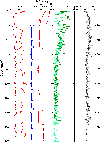
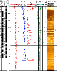
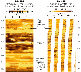
A selection of quality control logs are recorded along with the LWD data (see Figure 3. A, B, and C). The differential caliper log, which gives the distance between the tool sensor and the borehole wall, is the best indicator of borehole conditions. Differential caliper values are generally <1 inch over 90% of the total section in all the Holes, indicating an accuracy of ±0.015 g/cm3 for the density measurements. Only the uppermost 30-40 mbsf of the holes show washouts greater than 1 inch. In Hole 1244D the interval below 250 mbsf shows minor washouts due to borehole breakouts in the accretionary complex sediments, with differential caliper measurements up to 1 inch (Figure 3A). The bulk density correction, calculated from the difference between the short- and long-spaced density measurements, generally varies from 0 to 0.1 g/cm3, which shows the good quality of the density measurements. The bulk density correction values are slightly higher in the upper 30-40 mbsf. Time after bit (TAB) values remain relatively constant (around 10 min for resistivity and 80-90 min for density, except at Holes 1250B and 1251A due to higher ROP, see Figure 3C) coinciding with steady ROP while drilling. Some large variations in ROP are observed during pipe additions towards the bottom of Hole 1244D (Figure 3A). The depths, relative to seafloor (Table 1), for all LWD logs were fixed by identifying the gamma ray signal associated with the seafloor and shifting the log data to the appropriate depth as determined by the driller's pipe tallies. The quality of RAB images is high from all holes and no significant resolution loss is observed with variation in ROP. However, in the upper washed out interval between 30-40 mbsf, the images are somewhat degraded by an apparent problem associated with low rates of bit rotation. This is particularly apparent at Holes 1244D, 1245A, 1247A, and 1248A (see Figure 4) and these intervals should be interpreted with caution.
The RAB-8 tool, deployed in Hole 1249B, yielded high quality data to a total depth of 75 mbsf. Eight rotary cores were recovered from Hole 1249B with on average 32.9% recovery, similar to the recovery achieved in other holes drilled at the site (Figure 5B). Preliminary observations suggest that the recorded RAB data from Hole 1249B correlate well with the data from Hole 1249A. This successful test marks the first ever logging-while-coring experiment, which is new technology that allows for precise core-log depth calibration and core orientation within a single borehole and without a pipe trip.
Figure 3. Plots of quality control LWD logs: A, Hole 1244D; B, Hole 1247A; and C, Holes 1250A and B.
Wireline logging data quality may be seriously degraded by changes in hole diameter, but for the most part hole conditions were excellent during leg 204. Only Holes 1245E and 1251H showed some significant variability with caliper readings up to 17 inches over short intervals. Comparison of logs from successive passes show good repeatability of the data. The absolute depths, relative to seafloor, for all of the wireline logs were fixed by identifying the gamma ray signal associated with the seafloor (Table 1) and depth shifting the log data appropriately. HNGS and NGT data provide a depth correlation between logging runs. Logs from different tool strings may, however, still have minor depth mismatches caused by either cable stretch or ship heave during recording. Ship heave is minimized by a hydraulic wireline heave compensator designed to adjust for rig motion during logging operations.
Logging Units and Scientific Highlights
A large volume of data was generated during Leg 204
and only some key points or highlights are presented here. For further
discussion of the data and geological background see the Leg
204 Preliminary Report and the Leg
204 Initial Reports Volume and to access the log data themselves consult
the ODP
Logging Services database.
The logged section is divided into four "Log Units"
on the basis of changes in the LWD and wireline gamma ray, density, electrical
resistivity, and acoustic transit time measurements. All log units are
not necessarily represented at all the sites drilled, and do not correspond
necessarily to the same lithologic units (see summary
Figure
4).
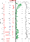
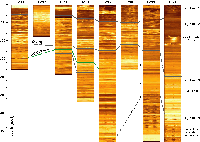
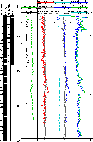
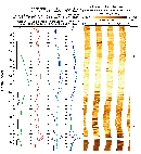
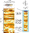
Figure 4. Summary plot showing RAB images from all the LWD sites drilled on Hydrate Ridge.
Log Unit 1 is present at all sites (Figure
4) and is characterized by increasing gamma ray values, resistivity
and densities with depth as measured by the LWD tools (Figure 5. A,
B
and C). This trend in the log data is probably
in part due to degraded log measurements within the enlarged portions of
the boreholes near the surface (see Figures 3 and 5). This is illustrated
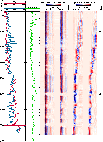
by the discrepancy between the core and LWD log density data at Site 1244
between 0-30 mbsf in Figure 5A. At Sites 1248,
1249 (Figure 5B) and 1250 (Figure
5C), at or near the summit of Southern Hydrate Ridge, high resistivity
values indicate high concentrations of gas hydrate near the surface in
Unit 1. At Site 1249, the logs dramatically reveal a 50-60 m thick, almost
continuous, gas-hydrate-bearing sedimentary section (Figure
5B).
The transition from Log Unit 1 to Log Unit 2 is
generally defined by a sharp increase in electrical resistivity, usually
accompanied by a more subtle increase in density and gamma ray values.
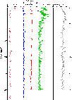
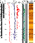
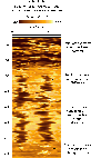
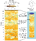
Figure 5. LWD data and corresponding RAB images from selected sites drilled on Hydrate Ridge. Log units and the position of recovered hydrate samples are also shown: A, Hole 1244D; B, Hole 1249A; and C, Hole 1250B.
Log Unit 2 is present at all sites except 1249 (Figure 4), and is characterized by zones of distinct high resistivity and high acoustic velocities (Figures 5. A and C and 6. A and B) associated likely with the presence of gas hydrate. The gamma ray logs in this unit show a characteristic cyclicity that may reflect the interbedded sand and clay turbidite sequences described by the shipboard sedimentologists for Lithostratigraphic Unit II. The LWD and wireline logs both reveal the occurrence of gas hydrate as high-resistivity zones and RAB or FMS image anomalies (bright intervals on the images). The resistivity logs allow for quantitative estimate of gas hydrate saturations (see Figure 5. A, B and C and the Leg 204 Initial Reports Volume). It should be noted that gas hydrate saturation is the measurement of the percentage of pore space in a sediment occupied by gas hydrate, which is the mathematical complement of Archie-derived water saturations (see Collett and Ladd, 2000). Where available, acoustic transit time logs were used to precisely select the depth of the boundary between Log Units 2 and 3, which is marked by a drop in compressional-wave acoustic velocity (see for example Figure 6B).
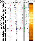
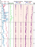
Figure 6. Wireline log data recorded from Hole 1244E: A, Triple combo logs; and B, Sonic logs.
Log Unit 3 is again present at all sites except 1249 (Figure 4), and generally correlates with the lower part of Lithostratigraphic Unit II or Lithostratigraphic Unit III, which is described as an interbedded sand, silt, and clay turbidite sequence. Log Unit 3 is usually characterized by lower and more uniform resistivity and acoustic velocities than Unit 2. Occasionally larger resistivity and density log variations occur below the zone of gas hydrate stability. These can indicate lithologic changes and/or the possible occurrence of free-gas. Gamma ray and density logs in this unit tend to show a cyclicity that may reflect the interbedded sand and clay turbidite sequences. The transition from Log Unit 3 to Unit 4 is marked by an abrupt drop in gamma ray values, bulk density and electrical resistivity (Figures 5A and 6A), and appears to mark the contact between the un-deformed sediments above and the deformed sediments of the accretionary complex below.
Log Unit 4 is present at Sites 1244, 1251, and possibly, 1245, 1247 and 1248 (Figure 4), and reflects the upper portion of the deformed sediments of the accretionary complex. It is characterized by highly variable gamma ray values, resistivity and density measurements that are in part the result of poor hole conditions but may also reflect lithologic variation. Borehole breakouts, which result from subsurface horizontal stress differences, are particularly well developed in Unit 4 (Figure 5A).
LWD data are not available for Site 1252, which was drilled at the end of the leg. The logged section in Hole 1252A is divided into two Log Units (Figure 7A). The boundary between Units 1 and 2 marks the contact between the sediments of the accretionary complex and the relatively un-deformed overlying sedimentary, which in other sites was the boundary between Log Units 3 and 4. Log Unit 1 has variable gamma ray, density, and resistivity log values, and contains several high resistivity intervals that may contain gas hydrate. Log Unit 2 corresponds to the upper portion of the deformed sediments of the accretionary complex and is characterized by almost constant gamma ray, neutron porosity, density, and resistivity log measurements.
Figure 7. Wireline log data recorded from Hole 1252A: A, Triple combo logs and sonic logs; and B, Enlarged portion between 112 to 127 mbsf with corresponding FMS images
Figure 7B shows an FMS image near the boundary between Log Units 1 and 2 in Hole 1252A. This FMS image includes both an anomalous high gamma ray zone in Log Unit 1 (114-121 mbsf) and a fine resistive layer near the top of Log Unit 2 (125-126 mbsf). The high gamma ray zone, associated with high uranium and potassium content, corresponds to an interval where glauconite was identified in the core. The resistive layer was identified as a fine carbonate unit.
RAB and FMS images
A large volume of FMS and RAB electrical images was
generated during Leg 204 and only some highlights are presented here. For
further discussion of these images, see the Leg
204 Preliminary Report and the Leg
204 Initial Reports Volume. The images themselves are available in
the ODP
Logging Services database.
Both the RAB and FMS produce high-resolution images
of the electrical resistivity of the formation around the borehole that
can be used for detailed sedimentological and structural interpretations.
Because of the insulating properties of gas hydrate, the images can also
provide informations about the nature and texture of gas hydrate occurrence
in the sediments. While the resolution of the RAB is considerably lower
than the resolution of the FMS (the vertical sampling interval is 3.05
cm for RAB images and 2.54 mm for the FMS), the RAB tool provides 360f
coverage of the borehole, against only 35% of coverage for the FMS.
Borehole breakouts, which result from horizontal
stress differences, are observed in several holes and are particularly
apparent in the lower portion of Hole 1244D (Figure
8A). The breakouts appear consistent with a ENE-WSW orientation in
the borehole and occur in the accretionary complex sediments.
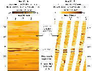
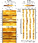
Figure 8. RAB images and corresponding FMS images from Site 1244: A, RAB image showing breakouts in Hole 1244D; B, Ash layer correlated in LWD Hole 1244D and wireline Hole 1244E; and C, Turbidite sequences correlated in Holes 1244D and E.
Comparison of similar log signatures reveals a ~5 m depth difference between Holes 1244D and 1244E, which can be explained by the 90m between the two holes. After taking into account this apparent depth shift, the LWD and wireline images match relatively well. In Figure 8B we compare a RAB image (Hole 1244D) and an FMS image (Hole 1244E) of an ash layer, identified by the shipboard sedimentologists at a depth of ~216 mbsf in Hole 1244C. The ash layer appears as a complex interbedded zone of high and low resistivity. The RAB and FMS images in Figure 8C, from Holes 1244D and 1244E, are characterized by interbedded light (resistive) and dark (conductive) layers. The darker, more conductive, layers usually represent the more porous coarser grained fraction of the turbidite sequence.
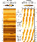
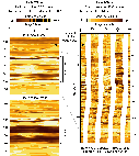
Figure 9. RAB images and corresponding FMS images from three of the LWD sites that intersected Reflector A: A, Holes 1245A and E; B, Holes 1247A and B; and C, Holes 1250B and F.
Figure 9 illustrates the response on the RAB and FMS images of a prominent seismic reflector, referred to as Horizon "A" (see the Leg 204 Scientific Prospectus). The RAB and FMS images from Horizon "A", which appears as a complex interbedded zone of high and low resistivity, are cross correlated for each site: Holes A and E at Site 1245 (Figure 9A), Holes A and B at Site 1247 (Figure 9B), and Holes B and F at Site 1250 (Figure 9C). Horizon "A" is encountered at four sites (Figure 4) and gives a similar response at each, perhaps thinning slightly southwards. On more detailed examination, the FMS images show distinct lateral variability within this interval and apparent fine scale sedimentologic structures. The comparison of the deep and shallow measuring RAB images also shows evidence of geologic controls on the infiltration of conductive drilling fluids into the formation, which appears more prevalent in the shallow measuring RAB image. It is interpreted that this zone is more fractured and variable than the surrounding sediments.
Gas Hydrate occurrences
The presence of gas hydrate was documented by direct
sampling, with several pieces of gas hydrate being recovered at most sites.
In particular, summit Sites 1249 and 1250 yielded abundant gas hydrate
samples. Other Sites including 1244, 1245 and 1248 yielded moderate amounts
of gas hydrate samples. Gas hydrate occurrences are generally characterized
in logs by increases in electrical resistivity and acoustic velocities.
Figure
5 shows where gas hydrate samples were taken in Sites 1244, 1249 and
1250. The depth of these samples coincides generally well with intervals
where gas hydrate saturation derived from resistivity logs indicate high
hydrate concentrations.
To complement these estimates, the electrical images
give a more complete picture of the distribution of gas hydrate in the
sediments.
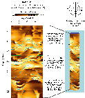
Figure 10. RAB images, unrolled and 3D representations with sinusoids picked to illustrate dipping fractures and bed boundaries, from selected LWD sites drilled on Hydrate Ridge: A, Hole 1244D, hydrate occurring in steeply dipping fractures; B, Hole 1245A, hydrate occurring both stratigraphically controlled and in dipping fractures; and C, Hole 1249A, massive hydrate, occurring disseminated within the sediment.
The RAB images in Figure 10 are from within the gas
hydrate stability zone in Holes 1244D, 1245A and 1249A. The RAB image in
Figure
10A is characterized by light (high resistivity) to dark (low
resistivity) bands, which can be traced across the display as sine waves.
These light continuous, high resistivity, sine wave bands likely represent
gas hydrate occupying moderately to steeply dipping fractures (dipping
50 to 80f to the E-NE) in Hole 1244D.
Figure 10B illustrates
similar occurrences of gas hydrate in Hole 1245A. The light continuous,
high resistivity bands, likely represent gas hydrate occupying low-to-high
angle fractures (dipping 40 to 80f dominantly E-NE), however, the
hydrate also appears to occupy nearly flat lying stratigraphic horizons.
The image depicted in Figure 10C is somewhat
different: it has a mottled appearance in addition to the presence of light
(high resistivity) bands. The light continuous, high resistivity bands,
likely represent gas hydrate occupying high angle fractures (dipping dominantly
40-80f NW). The bright mottled appearance of the RAB image may reflect
the occurrence of disseminated gas hydrate in the sediments.
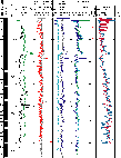
In addition, recent results by Guerin and Goldberg (2002) have shown that the presence of gas hydrate can generate a strong attenuation of the sonic wavefoms. Figure 11 shows the sonic logs and sonic waveforms recorded in Hole 1247B. The high sonic velocity and high resistivity between ~90 and ~130 mbsf coincide with low sonic waveform amplitudes, most significantly in the monopole wavefoms. While the nature of this energy loss is not yet explained, it could offer a new understanding of the nature of the interaction between gas hydrate and its host sediments.
Figure 11. Sonic logging data recorded in Hole 1247B. The presence of gas hydrate is indicated by higher sonic velocity and low sonic waveform amplitude, particularly in the monopole waveforms. These indicators coincide with high resistivity readings in the spherically focussed resistivity log shown for comparison.
Conclusions
During Leg 204, an unprecented number
of holes were logged, in generally excellent conditions, providing an exceptionnal
data set to help characterize the occurence of gas hydrate in marine sediments.
The successes of the logging program included the first deployment of RAB
tools in hydrate bearing sediments, and the first logging-while coring
operations. The LWD operations at the beginning of the leg, and in particular
the RAB data, provided an invaluable reference for most of the following
drilling operations. Wireline logs recorded in very good hole conditions
should provide additionnal insights into the nature of the hydrate deposition.
The sonic logs will also help integrating the entire data set within the
regional frame of the 3D seismic surveys, providing a complete picture
of the South Hydrate Ridge system.
Collett, T.S., and Ladd, John, 2000, Detection of gas hydrate with downhole logs and assessment of gas hydrate concentrations (saturations) and gas volumes on the Blake Ridge with electrical resistivity log data, in Paull, C.K., Matsumoto, R., Wallace, P.J., and Dillon, W.P., eds., Proceedings of the Ocean Drilling Program, Scientific Results, v. 164, p. 179-191.
Guerin, G. and Goldberg, D., 2002. Sonic waveform attenuation in gas hydrate-bearing sediments from the Mallik 2L-38 research well, Mackenzie Delta, Canada, J. Geophys. Res., 107(B5), doi: 10.1029/2001JB000556.
Horkowitz, J., Crary, S., Ganesan, K., Heidler, R., Luong, B., Morley, J., Petricola, M., Prusiecki, C., Speier, P., Poitzsch, M., Scheibal, J.R., and Hashem, M., 2002, Applications of a new magnetic resonance logging-while-drilling tool in a Gulf of Mexico deepwater development well: Proceedings of the Society of Professional Well Log Analysts Annual Logging Symposium, June 2-5, 2002, Paper 14p.
Rider, M., 1996. The geological interpretation of well-logs, second edition. Whittles Publishing, Caithness.
Schlumberger, 1989. Log Interpretations/Applications: (Wireline and
Testing): Houston, TX (Schlumberger).
Proceedings of the Ocean Drilling Program, Initial Reports
Proceedings of the Ocean Drilling Program, Scientific Results