ODP Leg 166 - Bahamas Transect Summary of Wireline Logging Results
Shipboard Scientific Party
Introduction
In this document we present a summary of the wireline logging results during ODP Leg 166. Details of the overall results of the leg can be found in the Leg 166 preliminary report located at the Texas A&M web page.
Background & Objectives:
Specific objectives of the Bahamas Drilling Transect/ODP Leg 166 were to:
1) determine the timing of the sequence boundaries and relative sea-level fluctuations during the Neogene;
2) determine the stratigraphic response of a carbonate platform to sea-level changes by analyzing the facies of the depositional sequences;
3) retrieve low-latitude isotope signals of the Icehouse World in the Neogene and Quaternary and compare it with the stratigraphic record to evaluate whether there is a causal link between eustasy and sequence stratigraphic pattern;
4) estimate the magnitudes and rates of sea-level changes using ages and recovered facies for a precise subsidence analysis.
5) assess whether fluid flow into and out of the platform along the margins occurs and by what mechanisms.
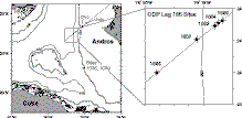
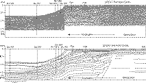
The transect of holes drilled along the western margin of the Great Bahama Bank during Leg 166, together with two holes drilled on the bank top, Unda and Clino, complete the Bahamas Drilling Transect (Figure 1) and Figure 2). Holes Unda and Clino continuously cored sediments dated from the Late Miocene to the present, and an extensive program of analyses has been completed, including bio-, magneto- and strontium-isotope stratigraphy, as well as of petrophysical analyses including wireline logs and core sample measurements. Results from the bank top drilling are reported in McNeill et al. (SEPM Contributions to Sedimentology volume edited by GN Ginsburg) and Eberli et al. (Proc. ODP, Initial Repts., volume 166).
|
|
Figure 1: Location of drill holes of the Bahamas Drilling Transect on the western margin of the Great Bahama Bank (GBB). Sites 1003-1007 were drilled as part of ODP Leg 166. Holes Unda and Clino were drilled on the bank top from a jack-up barge as part of the Bahamas Drilling Project (BDP). |
|
|
Figure 2: Seismic line (migrated GI-gun) across the western margin of the GBB, with interpretation of seismic sequence boundaries . Seismic line is a splice of multi-channel seismic line on the bank top acquired by Western Geophysical with a multi-channel GI-gun seismic line acquired on the R/V Lone Star as part of the leg 166 site survey. |
Leg 166 was quite successful in achieving its objectives right at sea or obtaining sufficient material for shore-based analyses that will enable their achievement post-cruise. However, core recovery averaged 53%, and several intervals had little or no recovery (see tables below). Therefore a detailed characterization of the facies and dating of sequence boundaries (objectives 1-4) could be compromised. Fortunately a suite of wireline logs were obtained at all deep penetration sites of the transect that will enable a reconstruction of the facies and bedding patterns within the sequences. Thus, logging data was of critical importance for the success of the leg, in particular those relating to the characterization of sequences and their bounding unconformities. The major highlights are outlined below:
a) Determination of precise depth to seismic traveltime conversion using check shot surveys: Because of the rapid changes in velocity downhole due to complex diagenetic alteration of the carbonates, sonic logs alone did not result in accurate depth-time conversion. The accurate determination of the depth of sequence boundaries seen in seismic data was of crucial importance to relate the stratal characteristics of the various sequences to the facies seen in the cores and their respective ages.
b) Characterization of lithology from logs: Core recovery averaged 53%, but was often much lower at depth. FMS images, together with geophysical and geochemical logs integrated to core data will provide an important complement to characterize the facies of sequences and the nature of the sediments across bounding unconformities.
c) Site to site correlations: Log signatures of many sequences appear to have unique aspects that will help with precise correlation across the transect. Pronounced changes in log characteristics across many sequence boundaries also will help to narrow sampling for biostratigraphic purposes, thus helping with precise dating of these boundaries.
d) In-situ physical properties:
Leg 166 assembled a rather unique, high-quality data set to investigate the petrophysical properties of carbonates. The sediments cored and logged represent nearly the full range of diagenesis in carbonates, from fully unconsolidated, passing through various stages of cementation and dissolution, to the presence of stylolites at deeper depths. The ranges of physical properties in these sediments also parallel those encountered in hydrocarbon reservoirs, and these data will be of great value to improve our understanding of diagenetic processes and the development of porosity in carbonate rocks.
e) Depositional cycles: Depositional sequences and their bounding unconformities are clearly expressed in the logs across the Bahamas transect. In addition, the logs display the fine-scale detail of decimeter to meter scale variations in sediment type and diagenetic alteration that will be important in characterizing the stratigraphic response of the carbonate platform to sealevel and climate changes.
Data summary:
Tables 1 and 2 below contain a summary of all the downhole logs obtained during Leg 166, including tools logged in each hole, respective depth intervals, and totals of logs obtained at each site:
TABLE 1 - Leg 166 Logging Operations
|
Tool String |
1003D |
1005A |
1005C |
1006A |
1007C |
|
Sonic-Induction |
1050-110 |
425-seafloor |
690-385 |
715-104 |
- |
|
IPLT |
1050-seafloor |
433-seafloor |
690-385 |
715-seafloor |
- |
|
FMS |
1050-110 |
- |
613-385 |
710-104 |
- |
|
Geochemical |
1050-450 |
- |
- |
- |
- |
|
Quad-Combo |
- |
- |
- |
- |
1155-seafloor |
|
Well Seismic
Tool (VSP) |
1050-120,
19 stations |
408-107,
6 stations |
538-389,
6 stations |
715-106,
13 stations |
1093-331,
10 stations |
TABLE 2 - Leg 166 summary statistics
|
Site |
Logging Data Totals |
Average core recovery* |
|
1003 |
1.05 km of logs + 19 VSP stations |
~40% |
|
1005 |
0.73 km of logs + 12 VSP stations |
~35% |
|
1006 |
0.71 km of logs + 13 VSP stations |
~90% |
|
1007 |
1.2 km of logs + 10 VSP stations |
~50% |
*Recovery within open-hole logged interval
Summary plots of the geophysical and gamma-ray logs for each site, including the core-recovery columns, lithologic units, major age boundaries, as well as core physical properties can be viewed by clicking on the respective link below:
Some technical highlights
Hole 1005A was the first Hole in ODP to be logged with the Schlumberger Integrated Porosity-Lithology tool string (IPLT). This tool string included a spectral gamma-ray tool (HNGS), a porosity tool (APS) and a litho-density tool (HLDS):
- New spectral gamma-ray tool (HNGS):
two Bismuth-Germanate scintillation crystals housed in Dewar better statistics, high-quality spectral data
- Eccentralized tool string, less borehole effects, particularly on porosity data
- New porosity tool (Accelerator Porosity Sonde, APS) High-energy, high-flux neutron source (14 MeV minitron), high-quality epithermal neutron porosity, neutron slow-down time -> formation Sigma measurement safer handling on board ship (no radiation hazard)
- Improved density sonde (HLDS) hardware and electronics
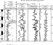
Figure 3 is an example of logging data obtained from the IPLT at Site 1005. Neutron porosity data in ODP often is of poor quality. Besides the fact that neutron tool does not have good resolution at high porosity, the tool could not be placed against the borehole wall since the early eccentralizers had too large a diameter. A new "in-line" centralizer is a significant improvement, since it ensures that the tool remains against the borehole wall. The array of neutron sensors also enables an estimate of tool standoff, which provides for quality control on the neutron data, analogously to the density correction factor (neutron data is considered poor when standoff is > ~1 inch).
|
|
Figure 3: Example of IPLT logs and core physical properties in Hole 1005C. |
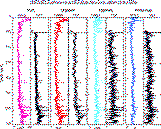
A comparison of the spectral gamma-ray logs obtained with the new HNGS tool and with the NGT is shown in Figure 4. In these carbonates, the gamma-ray signal resulted primarily from uranium, which in places reached up to 15 ppm. In the high uranium content intervals the tools compare well, although the HNGS log is clearly smoother because it has more counts and thus less affected by noise and statistical variation. The advantage of the tool is perhaps best displayed in sections where the total signal is low, due to only small amounts of clay (thorium and potassium signals) and uranium (probably associated to precipitation of uranium during diagenesis). In such cases, the high signal to noise ratio of the HNGS data allows for a much better resolution of the spectral components in the gamma-ray signal.
|
|
Figure 4: Comparison of shipboard spectral gamma-ray measurements with the NGT and the new HNGS tool in Hole 1006A. Note that empirical correction for pipe attenuation (above ~100 mbsf) was applied only to HNGS data. |
Leg 166 was first experimental deployment of a Ku-band communications sattellite, developed by OMNES (a division of Schlumberger).
- Ship->shore data transmission at ~1.5 Kbytes/sec
- Internet access
- Phone/fax line
- Simultaneous data/voice/fax links
Major advantages experienced during Leg 166:
- Near real-time logging data processing and evaluation on shore with improved analysis and interpretation ability on board the ship.
- Technical help from shore in real time (while logging).
- Access to shore files via Internet (ftp, remote login).
Scientific highlights:
Cyclicity in the sedimentary sucession:
Large scale changes in the physical properties of the GBB sediments, within units tens of meters in thickness, reflect major changes in the types of sediment and their diagenetic characteristics, which compose the major sedimentary packages or stratigraphic sequences bounded by unconformities (sequence boundaries). In particular pelagic oozes and chalks display a rather monotonous signature in the resisitivity logs, with a typical example being the Early Pliocene section recognizable at all sites (see summary Geophysical plots above). Changes in the degree of cementation are well expressed by increases in resistivity and velocity. The petrophysical properties reflect the alternations in the flux of neritic (aragonite rich) versus pelagic (low MG calcite rich) sediment. Gamma-ray logs appear to contain a more complex signature, including the effects of uranium precipitation as a result of diagenesis, as well as increases in the flux of clays. Hardgrounds and firmgrounds, probably formed during periods of low sealevel when sedimentation rates are reduced, have pronounced peaks in all petrophysical and gamma-ray logs. The influx of clay minerals, which probably come from Hispaniola and Cuba, are interpreted to increase during relatively low sealevel stands. The near surface sediments on the GBB margin (upper 20 meters) are composed primarily of aragonite, but both logging and core measurements show that they are very weakly radioactive. This suggests that the precipitation of uranium in these sediments occurs during diagenesis, although it is possibly controlled by the original composition of the sediment.
Packages containing calcareous turbidites and current-reworked deposits typically display high velocity and resistivity in the logs. The gamma-ray signature is variable and probably reflects the nature of the redeposited sediment. Asymmetric cycles with a "funel-shaped" resistivity signature are often present in association with intervals where cores suggest changes in grain size and sedimentary strucutures possibly caused by reworking by bottom currents (e.g., Site 1007 near 350 mbsf and Site 1003 near 400 mbsf).
Because the diagenetic potential of aragonite- and organic-rich platform derived sediment is high, the various forcing functions that affect the flux of platform derived sediments (such as sealevel and climate changes), are recorded in the petrophysical properties.
The relation between changes in the type of sediments accumulated along the margin and their diagenetic potential, leads to changes in the petrophysical properties which ultimately cause seismic reflections. Increase in the flux of metastable aragonite during relatively high sealevel changes, when the productivity in the bank increases, contrasts with the pelagic sedimentation which predominates during periods of low neritic input. Degradation of organic matter drives the diagenetic reactions and formation of cements and development of of porosity, which lead to pronounced log signatures. Because the sediment types change primarily as a result of sealevel changes, petrophysical properties and seismic reflections are accurately portraying the stratigraphic architecture of the margin and the changes in stratigraphy associated with sealevel changes. Changes in bottom-current intensity, perhaps associated with changes in the physiography of the Straits of Florida due to sealevel oscillations and carbonate platform growth, result in changes in the influx of siliciclastic sediments to the Bahamas region. The bulk of the sediments drilled were carbonates, but beds with secondary amounts of clay, likely brought by bottom currents from Cuba and Hispaniola during relatively low stands of sealevel, are clearly depicted in the logs.
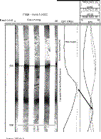
Superimposed on the large scale changes associated with the pulses of platform progradation are decimeter to meter scale changes in physical properties that probably result from high-frequency sea-level changes. These are particularly striking in the Miocene intervals. Cores reveal the alternation between darker bio-wackestones, with flattened burrows, and rich in organic matter and clays; and lighter bio-wackestones, that are well cemented and display open burrows. The well cemented bio-wackestones result from higher influx of neritic sediment, while a higher proportion of material of pelagic/hemipelagic origin (including forams and nannos, and clays) occurs in the darker intervals. These decimeter to meter scale cycles are well expressed in the sonic, density, porosity, gamma-ray and resistivity logs, including FMS images. An example of the expression of these cycles in the logs can be seen in Figure 5.
|
|
Figure 5: Log expression of small scale cycles in the Miocene at Site 1005. Shipboard logs not shifted with respect to FMS, arrow points to correlation between the gamma-ray curve in the FMS string and the gamma-ray curve in the IPLT string. RHOM=bulk-density, FPLC=far:near ratio neutron porosity, HSGR=spectral gamma-ray from HNGS tool. |
Spectral analysis (with contributions from Nathan Clark)
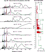
Preliminary spectral analyses on the wireline logs, using the shipboard biostratigraphic age models, reveal the presence of both precession, obliquity and eccentricity cycles in the Miocene. Example spectra from different sequences at Site 1003 illustrate (Figure 6): a) the consistent occurrence of Milankovitch periods at several age intervals, suggesting that the preliminary age models are probably of high quality; b) the consistent appearance of peaks at 30 ka and 54 ka, with a strong dominance of the 30 ka period.
|
|
Figure 6: FFT spectra of gamma-ray logs at Site 1003 for different age intervals. Age model is based on shipboard biostratigraphy. Logs have not been corrected for compaction. Note good consistency of peaks across age boundaries, with only minor shifts which are probably due to small errors in assumed sedimentation rates. The major peaks are observed at ~20, ~30, ~40, ~50 and ~100 ky periodicities. These peaks probably correspond to the Milankovitch precession band (19-23 ky), obliquity band (41 ky) and eccentricity band (54, 106 ky). The peak observed near ~30 ky in nearly all age intervals is characteristically strong, and further investigation and refinement of the age model is needed to verify whether that peak belongs to the precession or obliquity bands. Between 12.7 and 11.3 Ma the sedimentation rate does not decrease, and the record appears to be dominated by lower frequency oscillations. |
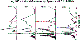
The availability of a well dated transect of closely spaced holes provides a unique opportunity to examine the nature of the stratigraphic response across the margin. For instance Sites 1005 and 1003 are close to the "carbonate factory" whereas Sites 1007 and 1006 are in a more distal position in the basin. The distal sites are presumably more affected by bottom currents, while still containing a record of the changes in the carbonate production on the bank. In contrast, the slope sites should be more influenced by changes in the flux of carbonates derived from the bank top. A comparative analysis of the spectrum for all sites within the same age interval should provide insights into the nature of the cyclicity along the margin, and whether these different processes are acting at similar frequencies. The analysis for a late Miocene interval (Figure 7) suggests that the spectrum is very similar at all sites, but while some of the peaks occur at the same frequency at all sites (e.g, 30 ka peak), others are shifted in frequency from site to site. This may be due to the fact that the log expression probably reflects the stratigraphic response of the platform to the various processes that build the margin. For instance, turbidites and current controlled bedding may be more prevalent in the lower portion of the platform, while the effects of changing the flux of platform derived material probably exert stronger influence in the stratigraphy of the upper part of the margin.
|
|
Figure 7: Cross-margin comparison of the gamma-ray spectrum between 8.6 and 9.5 Ma. Note the consistent presence of a strong peak at ~30 ka at all sites (lower sedimentation rate at Site 1006 is likely responsible for decreased amplitude). Variations in the frequency of other peaks may be related to the manner the platform stratigraphy responds to sealevel changes and bottom currents. |
Integration with seismic reflection data:
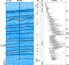
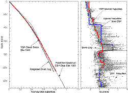
Check-shot surveys were performed at all deep sites of the transect. This proved to be a crucial step for the objectives of the leg because it enabled precise correlation of the seismic stratigraphic interpretation with the core and log data (Figure 8). The conversion from two-way traveltime to depth was of foremost importance to accurately place bio-stratigraphic datums with respect to the seismic boundaries, and therefore to achieve one of the key results of the leg, the demonstration that seismic sequence boundaries are time lines, and thus have chronostratigraphic significance.
Errors in time to depth conversion of up to 50 meters would have resulted if we had relied solely on the integration of the sonic logs (Figure 9). This is probably a result of the presence of large changes in sonic velocity at very small spatial scales, due to the common presence of cyclic alternations of well cemented and less cemented beds (e.g., Figure 8). In addition, it proved important to obtain VSPs at all margin sites because of the pronounced lateral variability in diagenetic characteristics of the bank margin, and thus of the velocity profiles. VSP acquisition was very time-effective, with an average of about 5 to 10 minutes per station, where we stacked 5-8 air-gun shots per station to obtain a travel time.
|
|
Figure 8: Portion of seismic reflection profile across Site 1003, showing correlation of seismic sequence boundaries (SSBs) with sonic log. Depth to SSBs determined from checkshot survey. |
|
|
|
|
Figure 9: Comparison of traveltime conversion derived from the sonic log, velocimeter measurements on cores (DSV) and from VSP checkshot stations. The interval velocities have a complex relationship with the high-frequency changes in the sonic log. Note that the integrated sonic log places sequence boundary "k" about 50 meters deeper than the VSP check-shot survey. |
FMS logs:
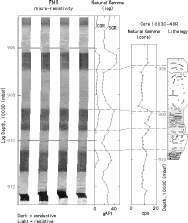
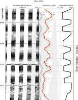
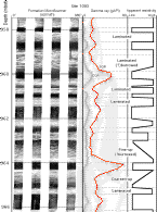
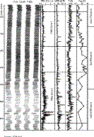
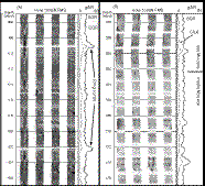
FMS data quality is very good in general except for the upper part of the open-hole logged intervals (between about 100 and 200 mbsf) in holes 1006 and 1003 due to large hole diameter. No FMS data was obtained in Holes 1005A and 1007C because the holes were found to be overall enlarged and because time constraints prevented drilling of dedicated holes at these sites. Examples of FMS images acquired at Sites 1003 and 1006 are displayed in Figures 10, 11 and 12A, 12B, 13 and 14. Detailed shorebased analyses of these images, together with other wireline logs and core data will provide a detailed picture of the litho-stratigraphic and petrophysical response of the Great Bahama Bank carbonates respond to sealevel changes.
|
|
Figure 10: Example of FMS image at Site 1003, displaying cyclic alternation of well cemented beds with open burrows (light-high resistivity and low gamma ray), and less cemented beds with flattened burrows (dark-low resistivity and high gamma ray). The darker layers also are richer in organic matter and clays, with a relatively higher porosity. Porosity in the darker layers is primarily moldic. The described core interval has been shifted based on the comparison between core and log gamma ray profile. |
|
|

|
Figure 11: Example of FMS images at Site 1003 displaying the contrast across seismic sequence boundary "l" (estimated age 12.7 Ma), between the flattened/open burrow cycles below and turbidites above. |
|
|
|
|
|
Figure 12 (A) and (B):Examples of FMS images and corresponding gamma-ray logs at Site 1003 displaying the variable expression of cyclic sequences. The schematic apparent resistivity profile to the right illustrates the nature of symmetric and asymmetric resistivity profiles, with both gradual and abrupt contacts. Abrupt basal contacts with upward decreasing resistivity are interpreted as turbidites. Gradual contacts above and below probably represent open/flat burrowed intervals similar to those shown in Figures 5 and 10.
|
|
|
|
Figure 13: Example of FMS image at Site 1006, together with spherically-focused resistivity, total gamma-ray and potassium content from the HNGS tool. Points on the right represent aragonite content derived from XRD analyses. FMS zones correspond to increases in the frequency of thin resistive layers, interpreted to result from increased bottom-current activity. Both zones display increased influx of clays from Hispaniola and/or Cuba (as indicated by slightly higher potassium content) and overall decreased influx of bank-derived sediment (as indicated by overall lower aragonite content). |
|
|
|
Figure 14: Detail of high-resistivity layers interpreted to represent lower sedimentation rates leading to the formation of firmgrounds. Decreases in sedimentation rate at this site are probably associated with increases in bottom-current speed. |
|
Opportunities:
Detailed depth matching of the core and log data will serve the basis for the construction of a continuous description of the sedimentary facies within the intervals logged. This integrated data set could provide a ultra-high resolution record of sedimentation on the Great Bahama Bank (GBB) slope, complementing core descriptions in intervals of poor recovery. Quantification of sedimentary cyclicity from FMS logs will enable resolution of very high frequency cycles, including sub-Milankovitch periodicity, even where sedimentation rates are relatively low. Detailed integration of log and core data will also enable a highly detailed investigation of petrophysical properties of the different carbonate facies and their expression in the logs.
Leg 166 Logging Scientists:
Carlos Pirmez - BRG, Lamont Doherty Earth Observatory
Judith McKenzie (ETH - Zurich, Switzerland)
Trevor Williams (LUBR - University of Leicester)


