The sediments in the Blake Plateau and Blake Nose situated in the western North Atlantic provide an ideal record for investigating variability in deep-water circulation and sediment history linked to climate changes during the Cretaceous and early Cenozoic periods.
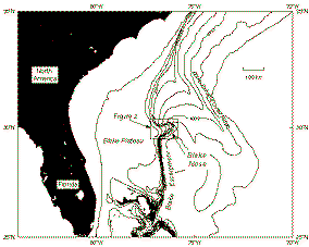
Blake Nose is a salient on the eastern margin of the Blake Plateau, due east of northern Florida (Fig. 1 and Fig. 2). Blake Nose forms a gentle ramp at the Blake Escarpment that reaches a maximum water-depth of 2700 metres. Paleogene to Barremian-Maastrichtian strata are exposed on the sea-floor, or, are present at shallow burial depths, as traced down-slope at Blake Nose. As continental margin subsidence was largely completed by the Early Cretaceous the present bathymetric profile at Blake Nose is comparable with that which existed in the early Cenozoic, once corrections for eustatic sea-level fluctuations are made. It is therefore possible to make unusually accurate estimates of paleowater depths for sedimentary cores taken from the paleoslope.
Figure1: Location map for ODP Leg 171B Blake Nose paleoceanographic drilling transect
Six shallow sites (170-680 metres penetration) were drilled along a down-slope transect from Blake Plateau towards the base of Blake Nose (Fig. 2) to produce a depth profile of cores. This transect provides information on water-depth dependent sedimentation, deep ocean chemistry, and biota that can be used to reconstruct past vertical structure and circulation of the western North Atlantic. In addition, the boreholes penetrate several major mass extinction event horizons, including the Cretaceous-Paleogene mass extinction boundary, providing valuable data to aid their interpretation. For full details of leg and initial results see Preliminary Report.
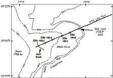
Figure 2: Drilling site locations for ODP Leg 171B transect and existing seismic lines
Scientific Objectives
The specific scientific objectives of ODP Leg 171B are:
Downhole logging program
A total of six shallow sites (170-680 metres penetration) were drilled along the Blake Nose transect over water-depths between 1293m to 2586 metres below sea-level (Fig. 2). Three holes, 1050C, 1051 and 1052E were logged using three wireline logging tool strings (Table 1). For individual tool names and a description of each tool see wireline logging tools.
http://mlp.ldeo.columbia.edu/research/technology/The wireline heave compensator (WHC) was unavailable on Leg 171B. However, during wireline logging, sea conditions were mild to moderate, with swell between 1 and 2.5 metres, and do not appear to have had any adverse effects on the quality of the logging data. Wireline logging data was successfully recorded for the total drilled length of all three holes from the bottom of the hole to the base of the bottom hole assembly (BHA).
|
Borehole |
1050C |
1051A |
1052E |
|
Water depth (m) |
2296.5 |
1982.7 |
1345.5 |
|
Penetration (mbsf) |
606.0 |
644.6 |
684.8 |
|
Base of bottom hole assembly (mbsf) |
108 |
110 |
222 |
|
Oldest strata |
Albian |
late-early Paleocene |
Albian |
|
Tools strings deployed |
Triple Combo* |
Triple Combo* |
Triple Combo* |
*Triple combo=Natural gamma (HNGS), porosity (APS), litho-density (HLDS), resistivity (DIT), temperature (TLT). No TLT on Hole 1051A.
**FMS-sonic= resistivity (FMS), sonic velocity (SDT). No SDT on Hole 1051A
***GHMT=magnetic field, magnetic suseptibility
Table. 1 Summary of ODP Leg 171B downhole wireline logging program
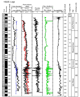
Hole 1052E
Hole 1052E is the shallowest water site of the transect situated on the upper part of Blake Nose (Fig 2). The borehole was cored from 140 mbsf to a depth of 684.8 mbsf reaching Albian strata, the only one of the holes at Site 1052 to do so. The borehole bottom assembly was placed to 222 mbsf due to major washouts in the uppermost part of the hole. Core recovery of the K/T boundary was recorded as occurring in the interval 309.7 to 319.3 mbsf. However, poor recovery in the core barrel containing the K/T boundary means that the boundary position cannot be fixed accurately from drilling and core measurement alone. The entire length of the borehole was logged by all three tool strings, with second passes being made between 339-236 mbsf covering the interval in which the K/T boundary occurred, to fix its position.
The wireline log data clearly identifies six large scale logging units which correlate well with the lithological units identified from core description. Boundaries between adjacent logging units were placed at simultaneous major changes in the characteristics of several logs (Fig. 3). The main lithological units determined from core description are all recognisable on the down hole logs and there is good agreement between physical properties determined from the wireline logs and core measurements.
Figure 3: Summary of selected logs for Hole 1052E
The top of Logging Unit 2 (295 mbsf) marks the position of the the K/T boundary and is seen on the FMS images as a shift towards more conductive lithologies. Within Logging Units 2, 4, 5 and 6 variability in log responses are consistent with metre scale alternations between carbonate rich and poor horizons. These .thumb-scale cycles are particularly well recorded on the FMS logs (Fig. 4) Climatically controlled small-scale sedimentary cycles may be more pronounced at this site due to its more landward position with the potential for relatively high terrigenous sediment input and clay content, compared to the deeper-water sites in the transect. Good quality FMS data should help produce a complete cyclostratigraphy stretching to the Albian that will complement the magnetochronology and biochronologies, and also assist stratigraphic correlations with Sites 1050C and 1051A.
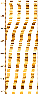
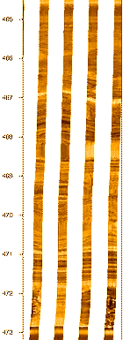
Figure 4: Selected interval of Formation MicroScanner (FMS) image (dynamic normalization) from Hole 1052E (low resistivity dark, high resistivity light)
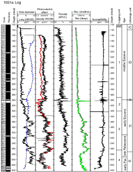
Hole 1051A
Hole 1051A is located midway along the Blake Nose transect (Fig. 2) at an intermediate point in the bathymetric slope profile. The Paleogene section at this site is more expanded than at the deeper-water sites, with younger sediments including Eocene deposits being present. The hole was drilled to 644.6 mbsf reaching Paleocene strata.
One complete pass with the Triple-Combo was made, with a repeat interval re-run between 456-356 mbsf. Two complete passes with the FMS and GHMT tool strings were performed. Log data was of good quality. Four large scale logging units were identified based on simultaneous variations across several different wireline logs (Fig. 5)
Figure 5: Summary of selected logs for Hole 1051A
Most of the wireline logs clearly define the structure and depth of the lower to middle Eocene unconformity, as well as a prominent interval of soft sediment deformation in the lower Eocene between 455 and 475 mbsf. Likewise, there is a pronounced peak in gamma-ray, thorium and magnetic susceptibility about 510 mbsf that correspond to the depth of the benthic foraminifera extinction horizon, lithological evidence of soft sediment deformation and an increase in clay content. The transition from the upper Paleocene siliceous nannofossil chalk to diatomaceous claystones is associated with a gradual down hole drop in magnetic susceptibility as well as increases in gamma-ray attenuation and uranium content.
The FMS produced high quality logs, with two separate runs being carried out to increase borehole coverage. Corrections were applied to take account of stick and slip caused by ship heave. In Logging Unit 2 the FMS identifies alternations between high resistivity chert bands and lower resistivity clay rich horizons. In Logging Unit 3 FMS images identify three zones of elevated resistivity at 460-466 mbsf, 510-545 mbsf and 560-585 mbsf that can be correlated to the geophysical logs and are caused by the increased frequency of thin (<0.4m) resistive beds. The FMS logs also pick out small scale sedimentary cycles marked by alternation between high and low resistivity horizons thought to reflect changes between carbonate rich and carbonate poor sediments. It should be possible to determine the orbital forcing patterns that these climatic sedimentary cycles record. The combination of resistivity and magnetic susceptibility down-hole data from the FMS, and lithological cycles described in the core, should help produce a complete cyclostratigraphy from the Paleocene to lower middle Eocene that will complement the magnetochronology and biochronologies, and also assist correlations between sites in the depth transect.
Sonic velocity (SDT) and temperature data (TLT) data were not collected in this hole due to electrical malfunctions.
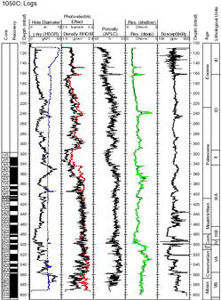
Hole 1050C
Hole 1050C was drilled at the deep-water end of Blake Nose (Fig. 2) late in the leg as an addendum to Holes 1050A and 1050B. It was the final hole drilled with the objective of obtaining an equivalent sequence of the Cretaceous section, especially the K/T boundary, to that recovered at the shallow-water Site 1052. The hole was cored from 320 to 606 mbsf, reaching Late Albian strata. The K/T boundary was found at 405.9 mbsf. Two successful runs of the Triple-Combo tool string were made for the entire length of the hole. One complete pass of the FMS tool string was made, but a second pass was cut short when it became apparent that a track left by the caliper tool on an earlier pass could be seen on the FMS image. One full pass of the GHMT was made and a repeat interval run between 260-213.5 mbsf. Plots of selected wireline logs are shown in Figure 6. Log data appears to be of good quality.
Figure 6: Summary of selected logs for Hole 1050C
Soft sediment deformation and chaotic bedding can be seen on the FMS image between 460 to 490 mbsf indicated syndepositional slumping during the Maastrichtian (Fig. 7). This correlates with slumping during the Maastrichtian decribed from core at Site 1052.
Figure 7: Selected interval of Formation MicroScanner (FMS) image (with dynamic normalization) from Hole 1050C showing shoft sediment deformation and chaotic bedding (low resistivity dark, high resistivity light).
Summary prepared by:
Ian Alexander - University of Edinburgh
Guy Spence - Borehole Research, University of Leicester
Trevor. Williams - Borehole Research, University of Leicester