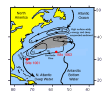
Between the northward-flowing surface waters of the Gulf-Stream and the net southerly flow of intermediate and deep waters, most of the climatically important exchanges of heat, salt, and water with other ocean basins occur in the westernmost North Atlantic. At the deepest levels of the western North Atlantic, Antarctic Bottom Water flows northward and blends with several other water masses in the deep recirculating gyres to form North Atlantic Deep Water (Fig. 1). The western intensification and flow of these waters erode the continental margin in some locations and preferentially deposit sediments at other locations known as sediment drifts.
Figure 1.: Map of deep water circulation patterns in the western North Atlantic (after Preliminary Report). Northern and southern origin waters mix in the southern of the two recirculating gyres. The numbers represent approximate transport in Sverdrups (1 Sv = 1000000 m3/sec), and the two logged sites are marked.
The main focus of Leg 172 was recovery of a sequence of high-deposition rate sediment cores from the Blake Ridge and Bermuda Rise sediment drifts in order to document rapid changes in climate and ocean circulation during middle Pliocene to Pleistocene time. Additional objectives were high resolution histories of geomagnetic field behaviour and biotic change, and biogenic methane and gas hydrate formation.
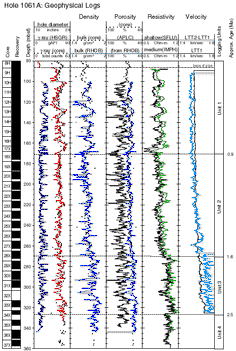
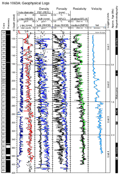
Most of the Leg 172 sites are located on a depth transect down the Carolina Slope and Blake Ridge to the Bahama Outer Ridge (1290 to 4725 m water depth), so that each of the major North Atlantic water masses, and their depth distibrution, is sampled through time (Fig. 2). Additionally, the two Bermuda Rise sites enable comparison across a geographical range in a contrasting setting further from land and closer to the gyre centre (Fig. 1). Most sites were triple cored to APC refusal (<200 mbsf) without deeper penetration, but two holes (1061A and 1063A) were cored to over 360 mbsf to cover the onset of Northern hemisphere glaciation (~2.8 Ma), and were logged.
For more detailed information about Leg 172, see the Preliminary Report
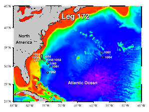
Figure 2: General Leg 172 location map, with bathymetry (by Gary Acton)
|
|
1061A |
1063A |
|
Location |
Blake Ridge |
Bermuda Rise |
|
Sediment Type |
Alterations between nannofossil clay and clay with silt |
Alterations between nannofossil clay and clay |
|
Water Depth (m) |
4046.6 |
4583.5 |
|
Penetration (mbsf) |
361 |
418.4 |
|
Age of base |
3.2 Ma (middle Pliocene) |
3.3 Ma (middle Pliocene) |
|
Triple Combo* |
86-361 mbsf |
87-416 mbsf |
|
FMS-sonic** |
86-351 mbsf |
87-416 mbsf |
*Triple combo=Natural gamma (NGT), porosity (APS), litho-density (HLDS), resistivity (DIT)
**FMS-sonic= natural gamma (NGT), sonic velocity
Table 1. Summary of the holes logged during Leg 172
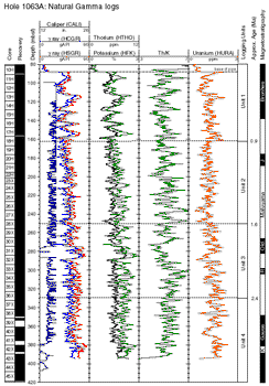
Despite being 1500 km distant from each other, the logs reveal Sites 1061 and 1063 to be very similar. They could each be divided into 4 equivalent Units (Figs. 3 - 6):
Unit 1 (0 - 0.9 Ma):
Long wavelength (~10m), high amplitude cyclicity in all logs. The interglacials are nannofossil clay, and have relatively higher porosity than the glacials due to the porosity contained within the nannofossils; the glacials are richer in clay, therefore having more radioactive K and Th, and hence relatively higher natural gamma counts than the inter-glacials.
Unit 2: (0.9 - ~1.6 Ma):
Shorter wavelength variations of more modest amplitude, mostly controlled by the same links as in Unit 1.
Unit 3: (~1.6 - ~2.4 Ma):
Similar to Unit 2, but lower porosity (hence higher bulk density, resistivity, and velocity). A higher Th/K ratio indicates that a lithological change (increased mixed layer relative to illite clay) accompanies the geophysical change in this unit.
Unit 4: (~2.4 - base of holes):
An abrupt downhole decrease in resistivity marks the top of Unit 4 in both holes; the unit is less apparent in the other logs.
|
|
|
|
Figure 3. Hole 1061A: Geophysical Logs (Hole diameter, bulk density, porosity, resistivity, sonic velocity). |
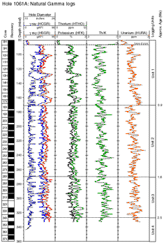
Figure 4. Hole 1061A: Natural Gamma Logs (Total counts, K, Th, U, Th/K) |
Log quality is generally good, but frequent narrow widenings of the hole diameter in both holes result in some intervals of bad density and porosity readings, due to bad contact with the borehole wall. In general, however, the logged density and porosity (calculated from density) match well to the core porosity and bulk density. APS porosity is usually over-estimated because of the bound and inter-layer water in the clays. Hole 1063 was bridged (constricted) between 275 - 285 and 380 - 400 mbsf, resulting in degraded logs over those intervals.
Below APC core refusal (150 - 200 mbsf), logs are offer superior measurements to equivalent core data, because the XCB cores were of low quality (biscuity), and have less than 100% recovery.
|
|
|
|
Figure 5. Hole 1063A: Geophysical Logs (Hole diameter, bulk density, porosity, resistivity, sonic velocity). |
Figure 6. Hole 1063A: Natural Gamma Logs (Total counts, K, Th, U, Th/K) |
The resistivity and natural gamma logs follow the known glacial-interglacial stages of the oxygen isotope record (Fig. 7), and can thus be dated. Stage 19 is pinned by the Brunhes-Matuyama boundary to 138.5 mbsf, and Stage 12 by the termination of P.Lacunosa to 95.8 mbsf, and between these tie points the pattern of the log falls neatly against the pattern of the isotope stages. The shape of the glacials and interglacials match well: glacial stages 16 and 20 are more prominent than the others in both isotopes and the logs.
There is a remarkable match in resistivity (and other logs) between Holes 1061A and 1063A (Fig. 7), considering they are separated by 14 degrees of longitude. Not only do the trend and detail of the peaks and troughs match, but so does their amplitude. The implications are that the same root paleoceanographic changes are responsible for the log (and lithological) variations seen at both sites, and that the general western North Atlantic circulation pattern (Fig. 1) has remained consistent over at least the last 1.5 Ma.
In Unit 1, natural gamma shows a strong positive correlation with resistivity (resistivity is largely a function of porosity, because the porosity is filled with conductive water). However, the story is more complex in Unit 2, where the upper part shows correlation between natural gamma and resistivity, but the lower part shows anti-correlation (Fig. 7).
There is an intriguing event at 160m (Fig. 7), near the mid-Pleistocene transition: a marked resistivity and gamma low. This level corresponds to a carbonate-rich (nannofossil ooze) layer at both 1061 and 1063. The repetition of the event at the two sites means that this paleoceanographic incident had a wide range, and may be associated with the change from 40 to 100 kyr cycles. The amplitude of the event is artificially enhanced in the logs because the ooze is more prone to being washed away than the surrounding sediment, and so the hole is wider at this level.
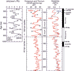
Figure 7. Comparison of: natural gamma with resistivity logs; resistivity at 1061A to that at 1063A; and the logs to the Specmap oxygen isotope (global ice volume) record. The logs clearly give the glacial-interglacial sequence, and the mid-Pleistocene transition from the '40 kyr world' to the '100 kyr world' is well defined. The Hole 1061A log has been transformed to the 1063A depth scale.
Future Work
1. Cyclostratigraphy. Correlating the 40 kyr cycles to axial tilt forcing and previously tuned paleoceanographic records from elsewhere will enable improved dating, calculation of detailed sediment accumulation rates over time, and a test of possible diachroneities in biostratigraphic datums.
2. Interpretation of Uranium logs. The Uranium logs at both 1061 and 1063 record the same 40 kyr cycles as the other logs. However, the mechanism by which Uranium becomes enriched in some layers but not in others is not clearly understood. Most likely it involves Uranium precipitation at redox fronts (where soluble U(VI) is reduced to insoluble U(IV)), but adsorbtion/complexation on organic matter could also play a part. A better understanding of the processes may enable the Uranium logs to be interpreted in terms of paleo-redox conditions during cyclic sedimentation.
Logging Scientist:
Trevor Williams, Borehole Research Group, Leicester University