I Common (and less common) problems already encountered
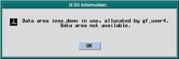
- When starting IESX, the following window pops
up, saying that the data area is already in use.
This might happen because someone else is using the project - in which case you have to find out who, and ask him/her to stop. But it can also happen if IESX or GeoFrame was not closed properly (crash, kill,...).
To fix it, select GeoFrame 3.8.1/Clear IESX Project in the Geonet window and enter the name of your project in the popup window. This sounds brutal, but it is not going to affect or erase any of your data - it is just going to deallocate the disk space where the project is so that you can use it.
- The wells and/or the logs do not appear on the
seismic line: there can be several reasons for that:
- The maximum distance in the criteria for well
appearance is shorter than the actual distance to your well.
- The display
and storage coordinate systems are not the same, or one of them
has not been set.
- There is no deviation
and/or checkshot survey for your borehole.
- A message appears in the log window with DB_E_PATH_..FAIL or Attempt to allocate zero/negative length buffer: this was encountered on the ship when multiple users had been connected to the same project simultaneously. This seems to indicate that some logical paths in the project are corruped (paths between object). You have to use the GeoFrame 3.8/IESX Utilities in the Geonet window - and select option 44: Delete db_physpath file
NB when using IESX Utilities, before running option 44, you have to initialize the access to your data area (i.e. project) with option 1. When you are done, you have to terminate access to the data area (option 2) before exiting (option 99).
- When plotting a seismic line, a blank image shows up - with only gridlines eventually: you are likely exceeding the maximum numbers of samples/trace to make the CGM plots - this maximum is 8192 samples/trace.
- When loading seismic data, you get a message saying
"
*I* Checking seismic
dsl spanning criteria
*I* Using percentage
free:
80.000 %
*I*
*I* /turf/brg0/scratch/DUH/Seismic/
*I* dsl size
: 233037618 kilobytes
*I* dsl available:
137492195 kilobytes
*I* percentage free:
58 %
****************************************
*Err * Spanning seismic
dsl criteria not satisfied
****************************************
This indicates that you exceeded the criteria for maximum storage percentage allowed for seismic data. This criteria can be useful for small disk file systems, but with large drives it makes it look that there is not enough space left, while there really is enough space for your data. This maximum value is defined at the time a project is created - but it can be edited or deactivated with the project manager. Select the 'Project
Manager' icon in the GeoFrame Application Manager, and hit the 'Storage
Settings...' button. Scroll down the storage types to 'Seismic' - and
you should see at the bottom of the window a line saying 'Percentage
of use before spanning (%) ' - with a default value of 95% . Uncheck
the red box to the left - and that will deactivate this criteria.
- When loading navigation data, IESX hangs - then crashes - you are likely exceeding the maximum number of navigation points, which is 32768.
- If you want to print a figure with a synthetic seismogram (i.e. make a cgm plot), you have to display the synthetics 'along borehole' in the borehole vertical appearance - otherwise, the cgm file will be corrupted and you won't be able to open it with npsuser or convert it with cgm2img
These are errors that we have already encountered - this list should be updated as our experience grows...
If your problem is none of these, it might be in
the GeoQuest archives
II Archive of Geoquest Technical Support for IESX
The documents in this appendix were downloaded from the GeoQuest Technical Knowledge Base. They include all the Errors, Bugs, Frequently Asked Questions (FAQ) and technical hints (How Tos) regarding IESX and associated applications that were addressed by the GeoQuest technical support until 4/24/2001. Some of these documents might refer to bugs that have been fixed - I did not check every single one of them. The purpose of this is mostly to offer at sea the support that we have routinely at Lamont - and to provide faster preliminary answers than through emails and requests to Lamont.
The fastest way to look for an answer is to useyour browser's 'find..' tool to look for a specific topic/keyword in the titles themselves. If this doesn't succeed, you can hope that your keyword is not in the abbreviated description of the error in the title - but might be in the more complete description in the archive files. The following step (on a unix machine) is then to go in the subdirectories with all the 'answers' (./Bugs, ./Errors, ./Howtos and ./FAQs) and use the grep command to find the keyword in any of the documents. If you go in any of these directories the command would be grep keyword *.
In each category, the numbers of the questions and documents are more or less chronological (based on the date of the request) - they do not have any significance in terms of relevance, gravity or priority.